Railway tales – a summary of some of my presentations: produced during Covid-19 lockdown!
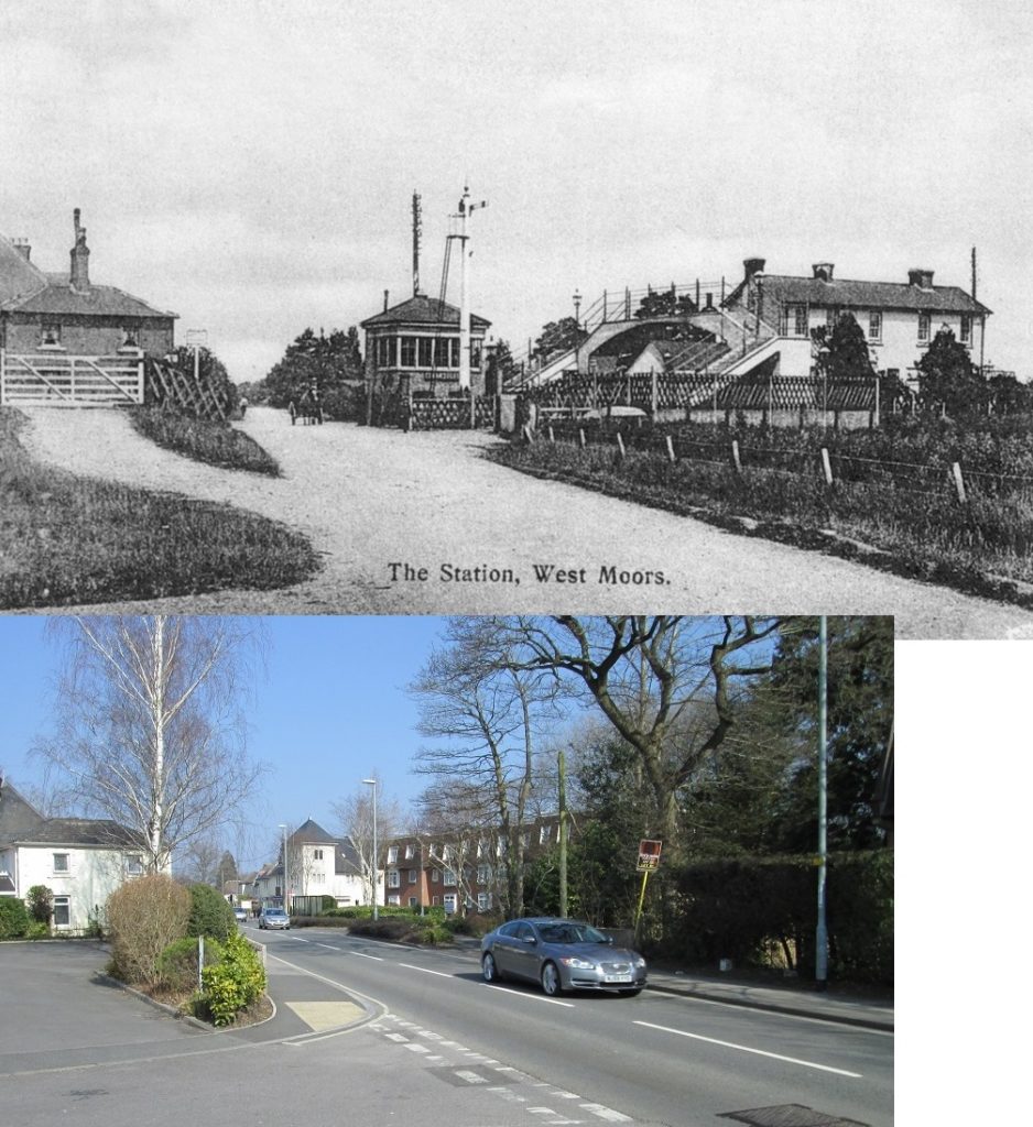
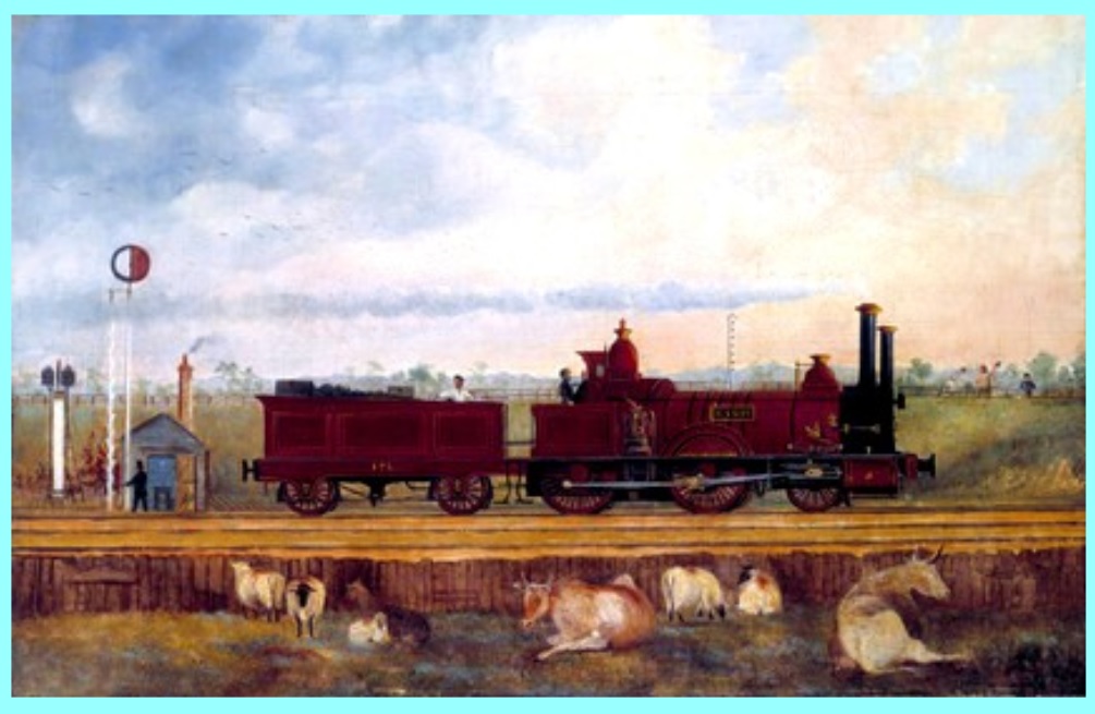
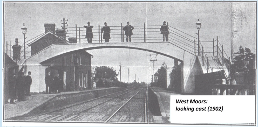
The opening slide of one of my presentations: top/left … the view of the iconic pedestrian concrete bridge over the twin tracks at West Moors Junction station – not too long after it was installed early in the 20th century (see text for more); bottom/right, the equally iconic three-arm up-line signal gantry protecting the junctions – Salisbury line (left-most arm) and Fuel Depot (middle-arm/circle charged). The right-hand arm control the section towards Ashley Heath.
… Not sure this is going to work out: but thinking about everyone stuck at home, and all these slides I’ve worked up over the years to give local presentations on West Moors history, I thought I’d try and start a sort of presentation here …. nothing fancy! I’ll simply upload one or two slides a day or so, then bash out some off-the-cuff notes about it …. here is the first slide I used for a presentation at the Library in 2016 (60 years of WM as a civil parish). Top left shows the footbridge erected in 1902 and bottom right shows the (I think unique) three-signal gantry controlling access to the junction; remember, the proper name of West Moors after 1866 (when the Salisbury line opened for traffic) was West Moors Junction. More on both of these artefacts in the days/weeks ahead.
Left-most image – Victorian era post box; central image – representation of a railway (single-track); top-right image – lineside telegraph/telephone pole; bottom-right image – bundle of newspapers ready for transport by the railway.
… This slide (above) is intended to demonstrate just how the coming of the national railway network radically changed the lives of folk in the middle decades of the 19th century. Newspapers had been around for some time of course, but now news from the great cities could be read in the provinces the following day – and reporters went out looking for news away from the great towns and cities; the public postal service too had been around since the 17th century, but the growth of the railways went hand-in-glove with increased use of written communication – and with that comes reduced prices (fixed price letters/pre-paid) and rapid distribution – goodbye to the Mail Coach! And the telegraph, its wires originally fanned out alongside the railways during the 1840s and 1850s and revolutionised communication. All needed the railway to work efficiently – and a ‘symbiotic’ relationship grew up.
Now all this might seem ‘sort of’ interesting – but its the reason why old duffers like me have a fascination for the growth of railway transport: you and I are living through just such a revolution – the internet and everything that flows from it have initiated a dramatic change in all our lives. Some of it bad, a lot of it good – just as happened in the middle decades of the 19th century. I’ll deal with the impact the coming of the railway had on our local area in later posts.
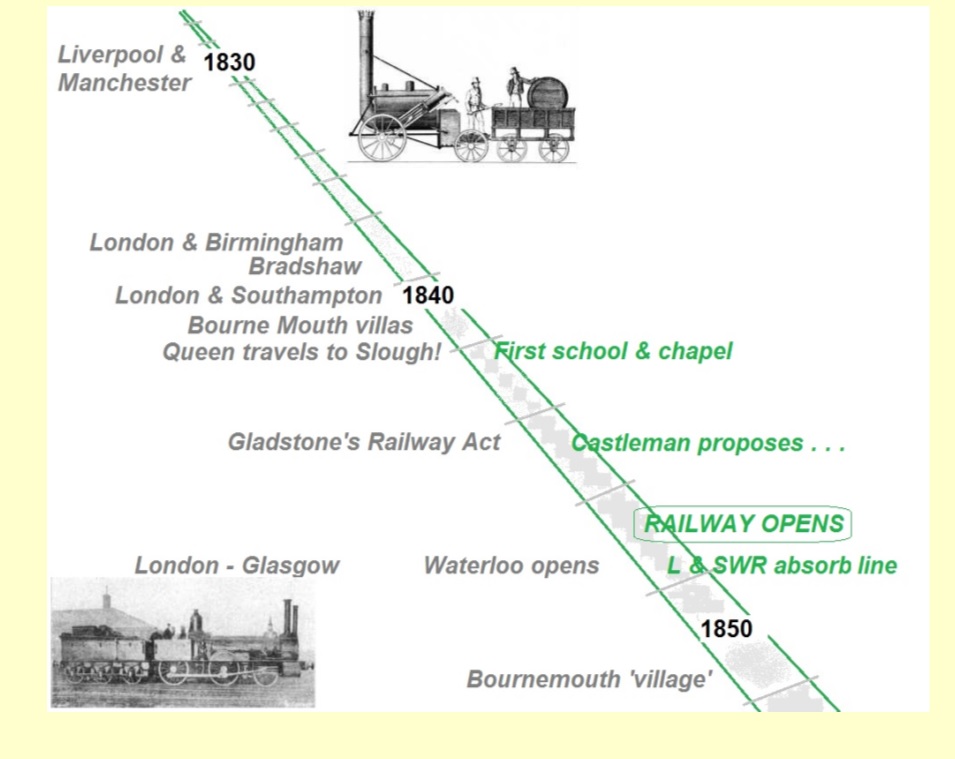
… this slide (above) was inserted in a presentation in 2017, as that year marked two “decade-defined” anniversaries in our railway story.
It was 170 years since the first main-line railway arrived in Dorset, connecting the county to the national network via Southampton, initiating changes in the life of Wessex after centuries of being dependent on travel achieved on foot or by horse power. The importance to us (WM) is that this ‘revolution’ began just over a mile east of the modern community – where the railway crossed from Hampshire into Dorset at the then county boundary running down the Moors River. Unfortunately, by the time of its closure, the line was regarded as a ‘branch’ – which masked its importance. The railway that came through West Moors was as important to Dorset as Brunel’s ‘Great Western’ and Stephenson’s ‘London & Birmingham’. Whereas their lines function today – for historic reasons (which I’ll cover later), our place in history has been wiped from the map!
2017 also marked 150 years of the opening of the first ‘proper’ station (actually a goods shed with loading bays – the full-blown station came a little while later) – and it could be said that the ‘community’ of West Moors owes its existence to this event – and again should be celebrated!
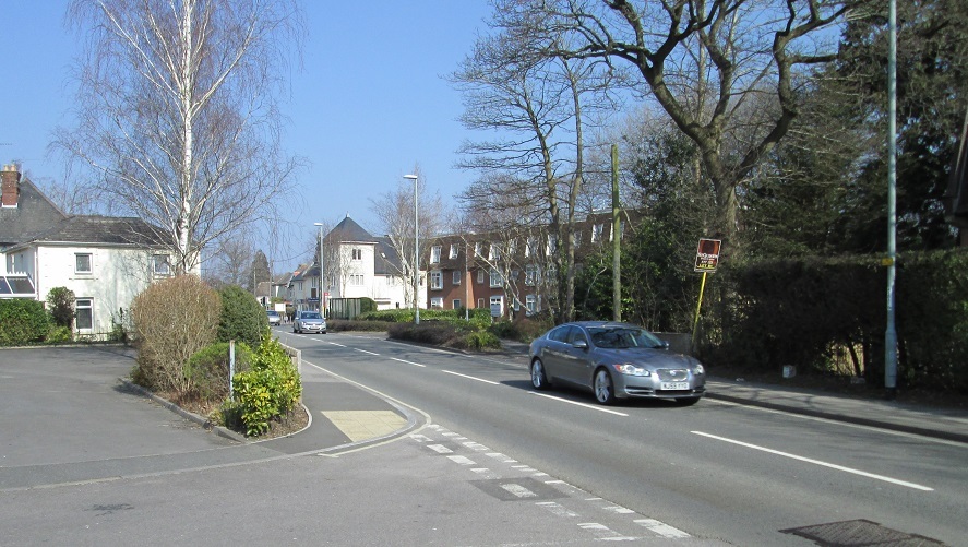
Station Road – looking north – early 21st century. Photograph taken from a point adjacent to the turning for Pinewood Court & Moorland Court. See the text for other information.
… Station Road (image above), looking north a few years ago. Centenary Court has been completed (white building with ‘pointy’ roof), and this side of it is Castleman Court. The latter is built on the land that once contained the Station buildings. The small, white, rather insignificant building on this side of the road, just behind the Silver Birch, is the only ‘solid’ reminder that once upon a time, a main line railway crossed this road. The line(s) ran just this side of the Railway Crossing Lodge, which is what this building used to be. It was built for the opening of the line in 1847, and controlled passage of very little ‘traffic’ across the running lines. A lot of people think that this building was /the/ station, but it was built just over 20 years earlier – though oddly, the crossing keeper would have ‘managed’ the adjacent siding for a time. A ‘then and now’ picture will follow this … eventually!
… and here (above) is a composite slide comparing the image put up yesterday (2014 vintage … BTW, I’ve named incorrectly … Centenary Place [ not Court]) with a view from as close as possible on the same spot looking towards the railway crossing. You can now see how the railway would have ‘lived’ in the environment. Dating the older photograph is a challenge: it must be after 1902 (erection of concrete footbridge); after 1904 (signal box moved from opposite the junction) but not too long afterwards, as the smoke-staining on the bridge isn’t that prominent. Also, we have a photograph from roughly the same spot (dating to the 1920s), and the vegetation has grown up steadily both alongside the roadway and behind the signalbox. Also, if you look very carefully, you can’t (apparently) make out any buildings /behind/ the signal box (i.e. the original shops in this area – demolished to make way for Centenary Place), and these were built late 1900s or very early 1910s: so I place this image as ‘Edwardian’. The signalbox also doesn’t appear to have the later large mirror of the 1920s, erected to help the signalman view underneath the footbridge – he needed to view that direction to see trains coming from Ringwood, off the Salisbury line, and much later, working into the Fuel Depot. West Moors Junction was never a very busy station for passengers, even in this pre-Great War heyday, and except for the passage of trains, it must have been a peaceful place. The gate on the left, which looks from this perspective to be just in front of the Crossing Lodge, is in fact two running-lines away from it and controls access to the downside (i.e., away from London) loading dock – probably the oldest of the small network of sidings at the junction. We haven’t got any photographs of course of the early days of the railway – but try to imagine this older view with ONLY the crossing lodge, gate and ramp leading to that gate: that’s all that would have been hereabouts until 1867 – for those living in the Lodge, a very lonely existence.
… I worked this slide up (above) to demonstrate where the arrival of Dorset’s first main-line railway fitted-in with the story elsewhere in the early railway age in this country. Top/left: early -> Bottom/right: later. The reason I did this was to counter the idea that the Southampton & Dorchester Railway was somehow ‘late to the party’! Given that we had no extensive heavy industry, and just the one port (Poole) linked, it is remarkable that the line didn’t get built until a dozen years later. Queen Victoria & Prince Albert travelling to Slough (for Windsor) in the early 1840s was a real boost to /passenger/ railway development – the rapid upturn in passenger usage led to Wm. Gladstone propelling his ‘Railway Regulation Act’ (1844) through Parliament which capped fares for Third Class (open carriages, no seats!) at a penny per mile and requiring all railway companies to run on every line, every day in each direction stopping at each station: these were (and still are, where they run) known as ‘Parliamentary Trains’. West Moors could be said to have its first ‘focal point’ with the opening of the combined School/Chapel in 1842, and as the slide shows, the Castleman campaign to bring the railway to our part of Wessex began in 1844, with opening in 1847. Bournemouth was a twinkle in the eye of the developers – more to say about all this as the presentation progresses.
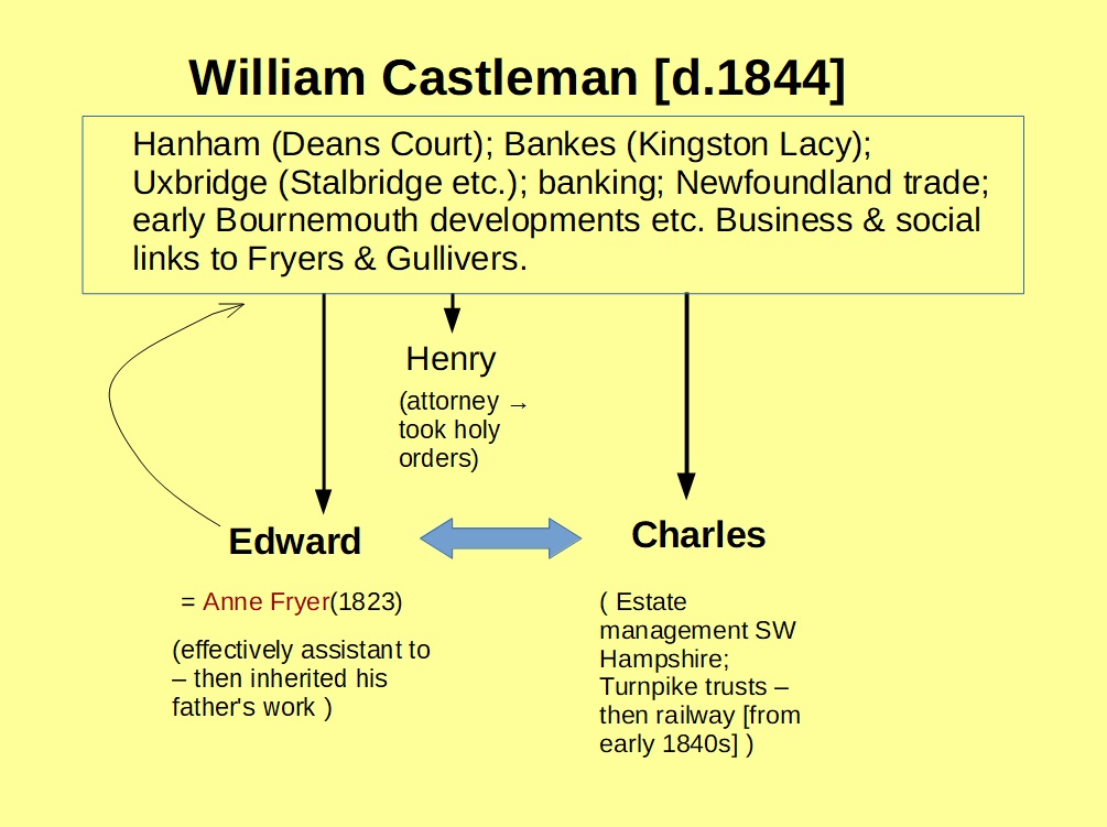
… and so we come to the Castleman clan! A little background on the family might be interesting – the diagram below summarises. William Castleman (Dad) had already made his reputation & fortune as a trustworthy land agent, attorney and manager to various ‘absentee landowners’ ( a common 18th & 19th century case) long before railways were a gleam in the eye of the local gentry. After the Napoleonic wars (when the continental blockade was lifted), local estates became impoverished and there was unrest amongst the tenantry. William was a ‘safe pair of hands’ and as the slide shows, accrued interests, or acted on behalf of, many of the major estates across north & east Dorset and beyond. He was ably assisted, once they had achieved their due education, by all three sons: Henry (his heir), again not unusually for the times, entered the church (of England) and only returns to our story as Rector of Christchurch when he was less than enthusiastic about a railway coming close by! The other brothers though, Edward and Charles, eventually took over the family business – Edward maintained the family presence in Wimborne, with Charles decamping to Ringwood. The slide summarises (probably poorly) their respective interests. Note the links to the Fryer & Gulliver families. More anon …..
Summary of the Castleman family tree around the time of the coming of the railway to Dorset.
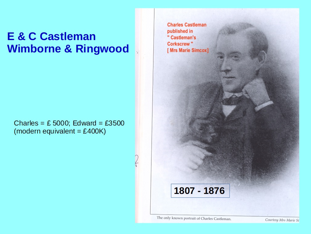
… The younger of the brothers, Charles (image below), is of course of great interest to us. He was already well versed in negotiating contracts with ‘transport’ in mind, as he was heavily involved in the administration of the local Turnpike Trusts – they owned / maintained the toll roads that had improved road travel since the second-half of the 18th century. The shorthand statement usually runs along the lines of ….. Charles Castleman, a Wimborne Solicitor, promoted the building of a railway (etc.). Sort of! First, he was by this time (early 1840s) a *Ringwood* practitioner, and as the previous slide indicated, the pure legal side of things was only one spanner in his toolbox! Through his family & business connections, he was approached to spearhead the bringing of the railway to Dorset & SW Hampshire – once the big landowners and other significant interests saw how its arrival had revolutionised life around Southampton after opening fully in May 1840. Charles was the right man, in the right place, with the right background to drive the project through. He became (almost self-appointed) both Secretary and Solicitor to the Southampton and Dorchester Railway when it was incorporated in 1844, and through his contacts & undoubted organisational energy succeeded in having the Act of Parliament receive the Royal Assent the following year. There’s lots of history surrounding the formation of the company and its aims … which I won’t bore you with! Needs another set of slides I think. Note the figures for investment by both brothers: £300K to £400K in today’s money (very roughly of course). They obviously were confident of success – and essentially success was achieved. But not without the help of another man …. more later.
Likeness of Charles Castleman. Taken from Jackson’s history of the Southampton & Dorchester Railway. The figures in the panel alongside show the personal investment each brother made in the company on formation.
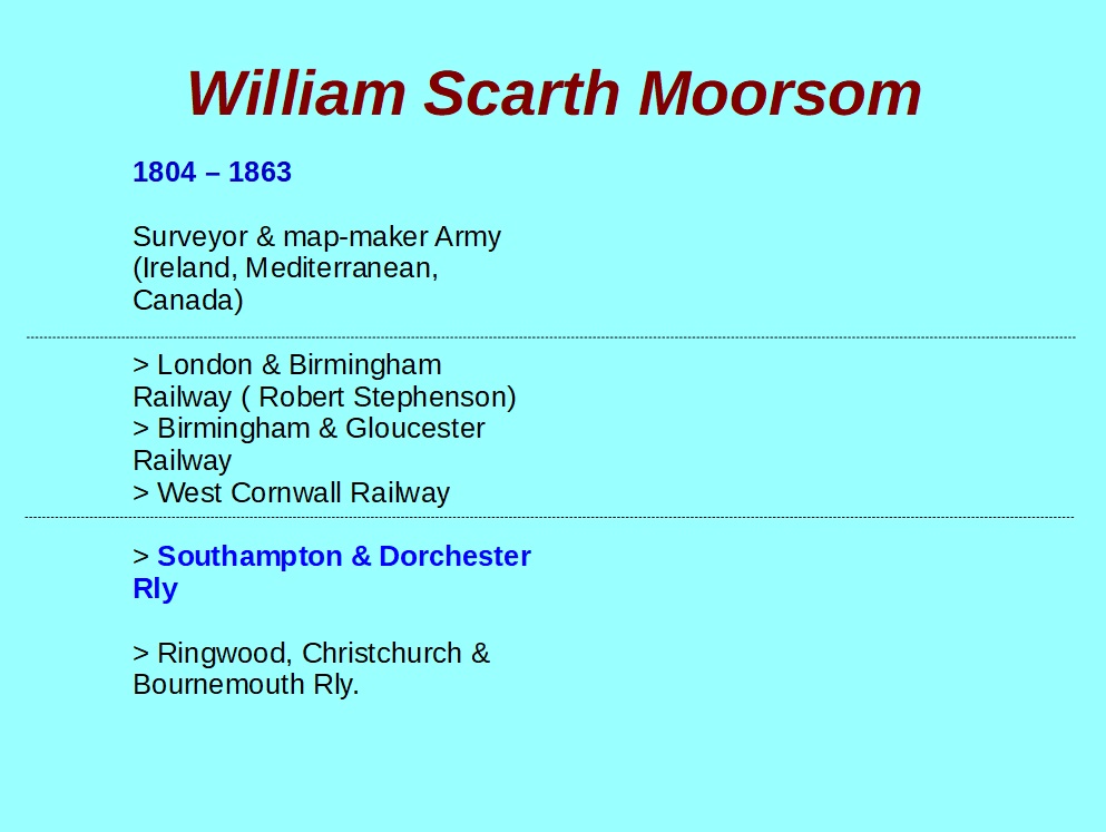
… and we now turn to the man who, in my view, should get much more recognition locally than he did: we all know ‘Castleman’ – you can’t go far round this end of the county without stumbling across his name. But Charles Castleman was no civil engineer or surveyor. What he knew about railways could be written on the back of a Penny Black! We need an expert …. Moorsom was such a man. Now you’ve probably not heard of him, but if Brunel and the Stephensons were at the head of British railways’ Premier League, then (army) Captain William Moorsom would be snapping at their heels in upper mid-table. The slide summarises his ‘form’ prior to being appointed consulting engineer to the S & D Railway – and by the 1840s, he had built a reputation for surveying and presenting plans for railways that used the geology of the country economically (i.e., they were cheap!) and served the needs of the community. Moorsom’s brief was … survey and build a railway from Southampton to Dorchester, making sure that the ‘Castleman towns’ of Ringwood & Wimborne were included, also Wareham – and with some sort of link to Poole port. Christchurch didn’t want a railway – a decision they regretted and they had to wait 15 years for one (Moorsom built that as well) and ” Bourne Mouth ” wasn’t really deserving at the time of rail connection. Moorsom set to with a will and presented his route – with an eye to a possible extension to Exeter! Of interest to us here in West Moors though is the route he took between Ringwood and Wimborne – we have Capt. Moorsom to thank, in my view, for West Moors as a community we know today …. I’ll try to explain that statement next …. but in the meantime, a slide that summarises Moorsom’s career – no photograph is known to exist of him (I’ve searched high and low!)
This slide summarises (in chronological order) some of the highlights of Moorsom’s life. As well as the railway projects noted above, he had a hand in surveying and advising on tasks, inter-alia, in Ireland (then part of the UK) and Ceylon (now Sri Lanka). His work in Canada (principally Nova Scotia) is well-remembered in that country to this day.
… Moorsom had many problems to overcome but I want to concentrate on the section between Ringwood and Wimborne – because his scheme gave birth to the community of West Moors. After all, why should West Moors exist? We have no ancient castle, no Tudor Manor House, no great meeting of rivers or significant river crossing. West Moors has no core of an ancient village or Roman settlement. Until the arrival of the railway, we were just a remote corner of Dorset, in a distant corner of West Parley parish. We had a railway station long before we had a church! Have a look at this extract of the first Ordnance Survey map of our part of the country. I’ve marked [ green circle ] where the modern-day Tesco Express is situated … I’ll leave you to peruse this map and make some comments in the next post … note the names – and note particularly where the cartographer has put the name ‘West Moors’.
Extract from the first Ordnance Survey map of the area containing West Moors; note that “New Br.” (i.e., New Bridge) near the green circle is an error: it should be ” New Fm “, that is New Farm (later West Moors Farm among other names). The “New Br” shown bottom/right IS correct, being where the current-day Palmsersford roundabout/bridge is over the Uddens.
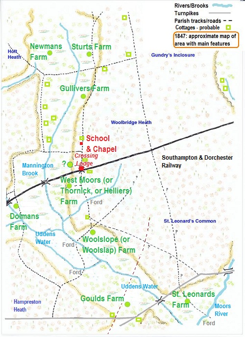
… referring back to the image in the last post, that map gives a good impression of the sort of country that Moorsom and his surveying ‘train’ would have traversed when he needed to work out where the railway should go. Several years ago, I tried to work out where all the human habitation was at the time of the railway’s opening in 1847; this was done using what maps were available, census returns and other data. This image (below) is my attempt to place where the farms, individual cob cottages etc., were in May of that year when the first scheduled train thundered across the track we now know at Station Road … no station of course – just the Crossing Lodge (without a name … just known as “Crossing No. 19″ or ” No. 19 Gates”) and the siding alongside. The “School and Chapel” was built a few years before – the ‘Chapel’ was really just part of the school (which itself was no more than a small room attached to a cottage) and not intended for the wider community. I’ve used the name ” Newmans Farm ” (not the modern-day version), but in 1847 it would be known as West Moors Farm. What we knew (before it was subsumed by the Farm Road development) as West Moors Farm was originally “New Farm” in the early 19th century, then named after the occupiers of the farm (as shown). Note the clustering of cottages along the boundary between the heathland (Holt Heath) and the farmed land. It is more than likely that it is this area (known in some census returns as “West Common”) that is the true ‘heart’ of the West Moors of the time. Gould’s Farm is roughly where Sainsbury’s is now.
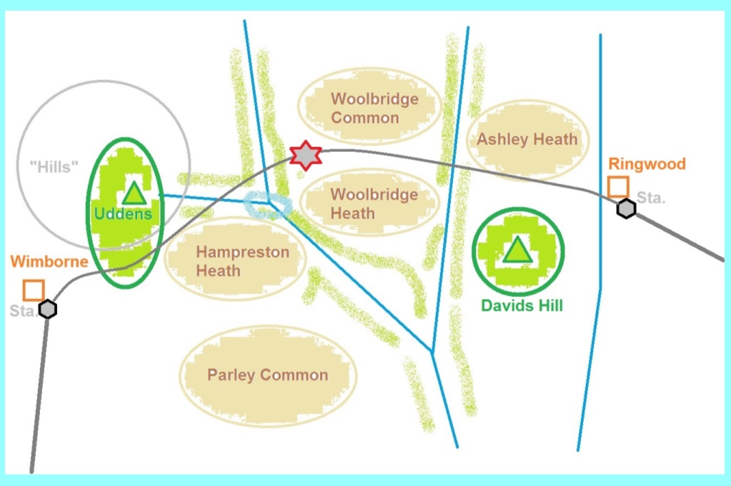
Look at this schematic map (above); Ringwood to the right, Wimborne Minster to the left. You are Moorsom. You’ve already been thwarted in your attempt to bring the line right across the New Forest – the Commissioners were adamant that the line must sweep well south, before coming in from the southeast to Ringwood – only the intervention of the Duke of Wellington ensured that the line entered the Forest at all! On the other side, the line has to point south towards Poole. It must avoid the Uddens Estate – the Greatheds, despite being major shareholders, don’t want a railway outside their front door! It has to avoid the boggy meandering Uddens water – would bump up the cost. It can’t run alongside the existing Ringwood-Wimborne Turnpike, because that would involve buying good quality farmland and building more substantial crossing lodges – adding to the cost.
So, you make use of the great expanse of moorland; no objection from the landowners – indeed the Fryers would make use of the railway to transport gravel to their properties! And by the time you’ve factored all this in, the railway crosses from east to west through an obscure part of Dorset – we’ll give it the name of the farm about half-a-mile away – West Moors (though remember no Station, not even a Halt). The Crossing Lodge (still with us) didn’t have a name: just “Gates No. 19”.
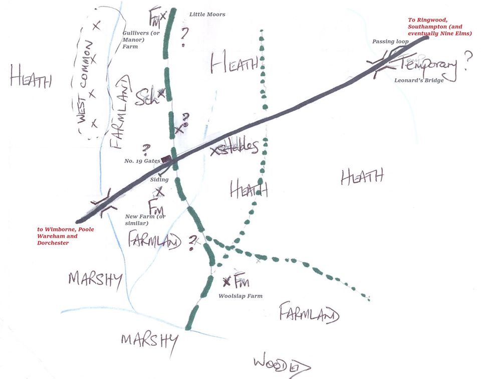
Rough sketch map of what the important features across ‘West Moors’ would have looked like when the railway first turned up …. see the text below …. [ Reading this later, I realise that I’ve implied a particular configuration for the ‘siding’ at West Moors: I don’t know how it was … it could have been like this, or ‘reversed’ ( i.e., a trailing siding ) or indeed a companion loop to the Leonard’s Bridge loop ( which would be logical if being used to shuttle loads of gravel to and from. ]
… OK, quite obviously a rubbish map! I needed to try and explain what ‘West Moors’ might have looked like when the railway first opened in 1847: there’s a map a couple of posts/images back which does a similar thing … but I wanted to concentrate on the area of the Crossing Lodge. The farms / farmland self-explanatory; two bridges crossing minor water-courses – at opening these were wooden – replaced later by current structures. The railway was single track – except at ‘Leonards Bridge’, a temporary cross-over (to allow opposing trains to pass) which probably also had facilities to load gravel: this closed only a few years after opening. The ‘stables’ are roughly in the area of the modern-day Arnold Road (near where Mary Lane ends) and emphasises that horses rather than engines were extensively used to transport supplies up and down the line. It is thought that these formed the basis of the later Railway Cottages – but the exact transformation isn’t known. By the way, if you’ve ever wondered why railway folk use the term /Permanent/ Way, it’s to distinguish from the ‘temporary’ way (rough ballast laid along the surveyors line) which was used to transport wagons with sleepers, rails, building materials and other supplies along the line. Once the main sub-structure of ballast, sleepers and rails are laid, then it becomes the permanent way! And steam engines can ply their trade. Note the siding opposite the Crossing Lodge – initially used to allow gravel to be transported up and down the line, but later, carriages could be detached to allow those who could afford it to travel ‘cross-country’ to the growing resort of Bournemouth – avoiding the bottleneck of Poole/Hamworthy. The ‘x’s show where we’re certain habitation was in place; the ‘?’ are suspected/possible cottages. Note the cluster of cottages at ‘West Common’, south of West Moors Farm (off the map to the north) already described. If there don’t seem many places of habitation at this time – that’s right! My analysis of the 1841 and 1851 census returns would suggest no more than 70 people living within the area shown on this sketch – adults and children.
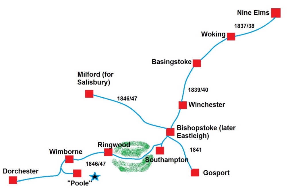
… The first regular trains begin running in summer 1847. This map (below) shows how the Southampton & Dorchester Railway links in with the rest of the ‘South West’ network. The ‘Southampton’ shown is not the station we know today; it was (for those that remember back the 60s) Southampton Terminus – the original end of the line from London. Dorchester trains had to curl in from the north until 1858 when a ‘chord’ was built to allow services to run direct from the north to the west. Poole is also not where we know now: it is actually on the Hamworthy peninsula – and to get to Poole town you had to cross by a rather rickety wooden bridge with steep approach on either side – this may be why West Moors siding was used to offload the carriages of the wealthy so they could go ‘cross-country’ and avoid the rather roundabout method of reaching the now growing Bournemouth ( the star ). Take a moment to consider what it must have been like on the night of the 1st June 1847. For centuries, the only sound across rural Dorset was the sound of cattle, foxes, owls etc., and the family gently snoring away in the farm houses scattered about the countryside. On this night, after a hard day’s work in the fields, about 11 o’clock the clatter, rattle and whistle of the ‘Up’ Mail trains sweeps up from Wimborne on its way to Southampton; once that annoyance is out of the way, our family drifts off to sleep …. only to have a repeat performance at about 1.30 am when the ‘Down’ Mail thunders through on its way to Dorchester! Life would never be quite the same.
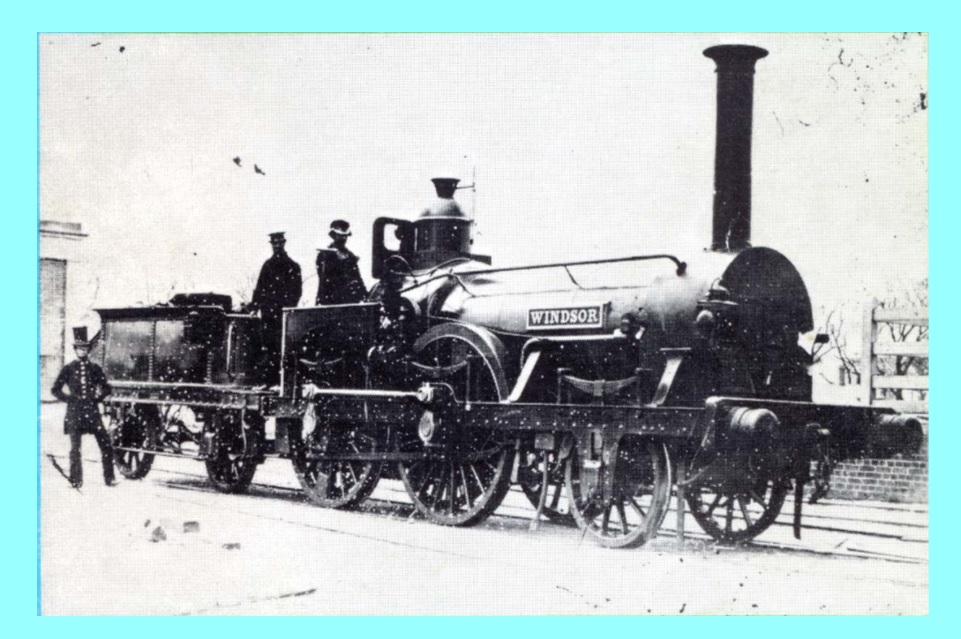
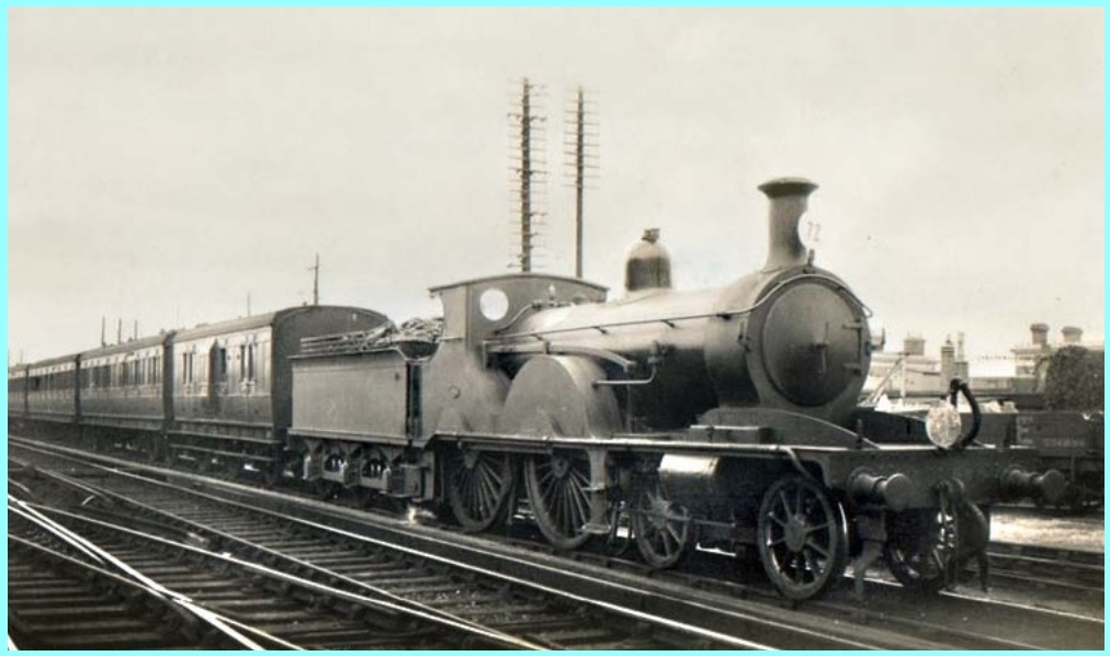
Locomotive ” Windsor ” 2-4-0 in 1852 seen at Dorchester – then the ‘end of the line’ that ran through West Moors. Designed by Joseph Beattie / L&SWR & built at Nine Elms depot.
… A typical locomotive (above) that would have passed through West Moors in the early days of the railway. This one was based at Dorchester – primarily intended for freight traffic but early trains were often ‘mixed’ with passenger and goods stock mixed together – a practice what was to be frowned upon in later years. It’s clear to see the ancestry of the earliest engines such as ‘Rocket’. Engineer & Fireman completely exposed on the footplate – a hang-over from the days of the Stage / Mail coach – except these beasts were travelling at some 25 to 35 mph into the weather! No overhead protection and just a simple plate with ordinary glass that the driver could look through to see where they were going – known as a ‘spectacle’ plate for obvious reasons. The rather splendid figure standing just to the side of the tender (for coal and water) is a railway policeman. He would have some functions of a traditional police constable, but his primary job was to ‘police’ the traffic on the line: it was his responsibility to control the traffic by means of rudimentary signals according to the timetable. At this time (1840s, 1850s, 1860s) we’re some way off the classic signal-box controlling block sections that we’ve all grown up with. When that system did come into play, signalmen were often referred to as ‘Bobby’ in a reference back to these earlier days.
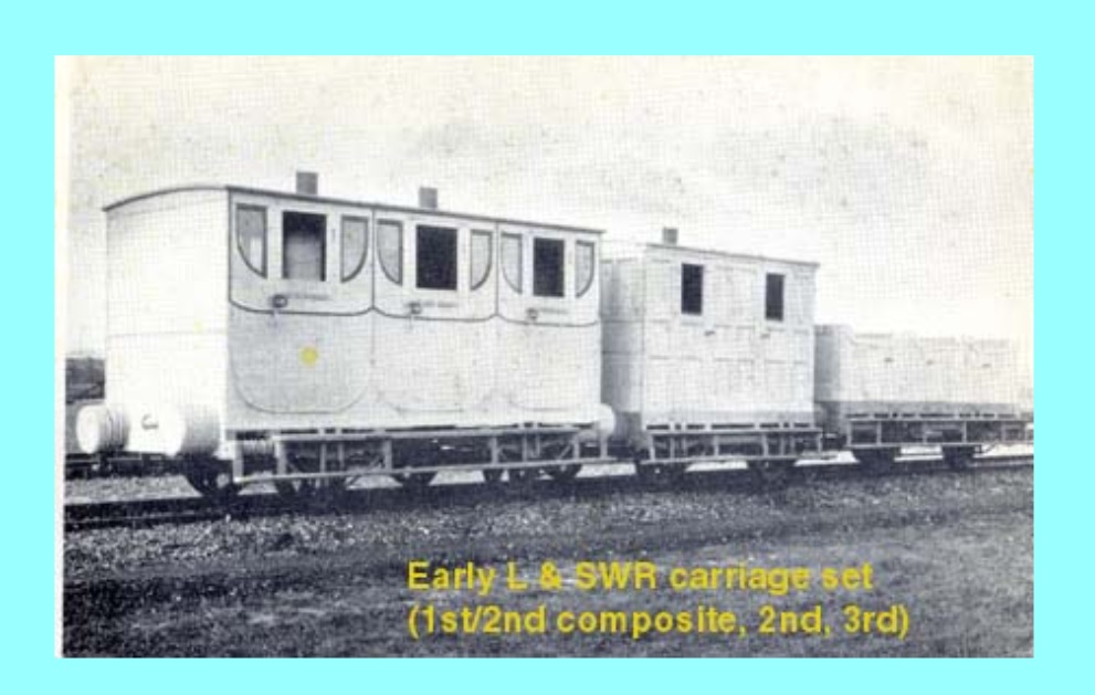
… and behind the locomotive, the train set! Very basic stuff in these early years of railway operation: this image (below) shows the range from First to Third class … First to a reasonable standard, with enclosed carriages, glass in the windows, cushions on the seats, finer upholstery etc: note the profile similar to the earlier horse-drawn carriage. Second class a ‘stripped-down’ version of 1st: not much ‘plushness’ on wooden seats, smaller windows (must have been claustrophobic – especially at night) but at least the carriage is enclosed. Third though different – really they were open wagons/trucks with wood planks to sit on – and just as in the days of the ‘outside’ passenger on a Stage/Mail coach, open to the elements, branches overhanging the tracks … and soot etc., from the engine! The buffers between carriages were simply horse-hair stuffed pads and the wheels were mounted directly onto the body of the wagon in all classes – this means a very hard ride -it would be quite late in the 19th century before wheel-sets were mounted on sprung bogies, which in turn were allowed to swivel to the curves of the track. In these early days, with poor construction techniques (the Southampton & Dorchester was not well built initially), the ride for ALL classes would be uncomfortable. No toilets of course – for the ‘poor folk’ they had to rely on lengthy stops at stations – 1st class could take a ‘convenience’ on board with them – but hardly pleasant; again, if you’re one of the posh folk you could hire a hot-water warmer from the railway – not so for the others. No communication with the Guard – the best anyone could do was lean out of the window and try to attract his attention. The things poking up from the 1st class carriage compartments are lamp holders: the railway staff would come along after dusk and let down a lit oil lamp to light up the compartment. OK if there were no sudden braking moves (or god-forbid an accident), but lethal if any sort of emergency occurred – fires were common. Finally, look at the small hook for coupling on the leading carriage. Although steel would eventually become normal – in the earliest days, a twist of rope of similar breadth to those use to tie up ships was used. Not bad if maintained properly – but over time, the rope frayed and it was not unknown for carriages to become detached – another job for the railway policeman – count the carriages and make sure that none were missing!
… For a few posts, I want to move away from the purely local scene and consider events on the south coast: the development of Bournemouth – our ‘Nemesis’!
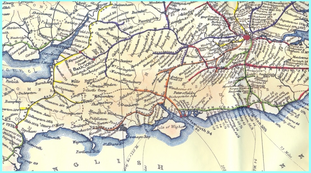
Have a look at this map from the Bradshaw’s timetable publication of 1852, just 5 years after our local line opened.
See how almost every English county within the field of view is connected to the national railway network at this early date – only Cornwall has yet to join in the fun – and that’s because Brunel hasn’t built the Royal Albert Bridge across the Tamar – 1859 will rectify that.
All the ‘first’ main-line railway lines you see here have survived into the modern age – not only survived but thrived! The Great Western, the ‘West Coast’ main line through the NW Home Counties, the ‘East Coast’ main line through Hertfordshire, the long-since electrified line to Brighton, the Southwestern lines through Surrey and Hampshire and the principal line through Kent … and so on, but NOT the /first/ main line into Wessex! Despite the fact that until the early 1890s it was THE principal line into Dorset and on to Weymouth – grass, saplings, blocks of flats & care homes now take the place of the former ‘Permanent’ Way.
The next posts will try to explain why ….
Extract map from “Bradshaw’s”, 1852
… If you look carefully at the map attached to the previous post, you’ll be hard put to find Bournemouth – because it isn’t there. Mind you, neither is Christchurch (just the ‘Christchurch Rd’ station which later became Holmsley).
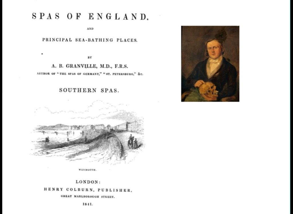
But one man /did/ know where Bournemouth was – not only that, but he appreciated that the location was worthy of mention: his name was Augustus Bozzi Granville. I’ll try and tell you something of this remarkable man.
The ‘Bozzi’ in his name will give a clue to his origin. He was Italian – born (Augusto Bozzi) in Milan – long before the days of a united Italy.
He studied medicine but to avoid being conscripted into Napoleon’s army, he departed and plied his trade across the Mediterranean and Iberia, finally enlisting in the Royal Navy and sailing for the West Indies. He learned English, married an Englishwoman and on leaving the Navy, set up practice in London as a physician and writer. His professional life would make an article all of its own – he was a pioneer obstetrician and gynaecological surgeon for example … but it’s his work investigating the health-giving properties of various British Spas that interests us. He had two goes at it: the first, in the latter 1830s was only a short, preliminary version of his published work – in 1841 – entitled ” The spas of England, and principal sea-bathing places” (see image below). Quoting just one sentence from that tract: ” members of my profession …. who will then know where to send with full confidence all such patients as require the combined benefit of sea and land influence such as is possessed by Bournemouth. “: There was no turning back! More next time ….
… Dr. Granville’s reputation was such that not only did /his/ patients spend time in Bournemouth – but through word-of-mouth and his writing, his medical peers, who were attending the wealthiest classes in the land through their London practices, also steered such folk towards the ‘Health Resort’ of Bournemouth. It’s difficult to assess the historic population of an area but using the available census returns for 1841, the ‘resident’ population has been assessed as circa 400 (but does depend on how ‘Bournemouth’ is defined). Even by the 1851 census, a ‘best guess’ would be ~700 and 1861 ~1700: hardly a dramatic increase over these decades.
[ For comparision, Wareham, Wimborne & Ringwood had populations in the 1840s->1860s (very roughly) in the range 3.5 to 6 K, and Poole was about 8 – 9 K ]
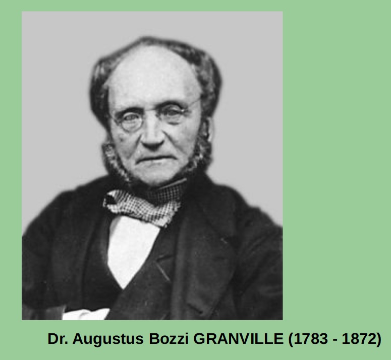
In the early days of growth of Bournemouth, only the very wealthy ‘top 5%’ of Britons could afford the travel to Bournemouth: this is NOT the bucket and spade era! The image of Granville here (below) is later in life – he must have looked back on his career with some satisfaction. He died in 1872, aged 89, a good age for the times, and he would have known that his words and deeds had initiated a revolution down on the south coast – not only in medical terms but in the railway landscape – which I’ll try and map out next time ….
… Dr. Granville’s patients travelled First Class: and they brought their ‘retinue’ with them. Not just the servants, but horses and carriages too! The faretables published in 1850, for example, show these costs for a journey from London to Poole: 63/6 (~£3.17, or very roughly £250= in today’s money-worth ) for a carriage & two horses, in addition to the costs of the fares for the principals & attendants.
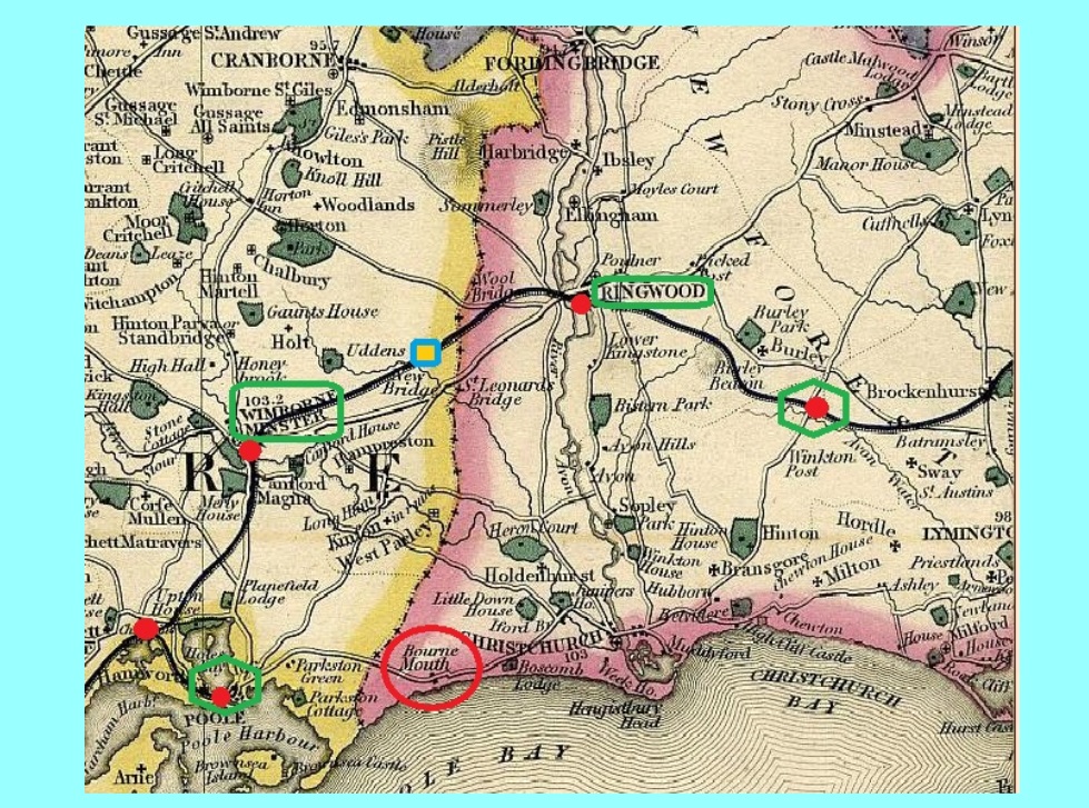
How did they get to Bournemouth? The map attached (below) shows the railway ‘landscape’ from 1847 until 1860. The ‘preferred’ route (as advertised initially by the railway) was to go to Poole , then come cross-country to Bournemouth; as already described, this didn’t find much favour for a variety of reasons. Neither Ringwood nor Wimborne were that convenient as the principal roads ( Turnpikes ) didn’t go direct to Bournemouth. Another option was to drop off at ‘Christchurch Road’ (later Holmsley) but this still involved a bit of a trek longer than that if you go to Poole. For those ‘in the know’ though, and for a fee, the train could be stopped at West Moors (the blue/yellow square), make use of the siding installed there and travel via subsidiary roads which had relatively easy gradients – and avoided passing through populated areas. We don’t know much about this activity and I suspect it was a rather haphazard enterprise – but just leaping ahead a little, it would place West Moors in the minds of the ‘great and the good’ when the likes of the Stewart brothers were looking for a base in southern England.
This map dates from the early 1850s: Note the pockets of green-shaded ‘parks’ which denote the homes of the wealthy and influential. A goodly clustering of same to the west and north of Wimborne Minster, hence the requirement for a main line to that place, rather than a branch: “Bourne Mouth” just about makes it to the map – and of course it, along with Christchurch, is firmly in Hampshire.
… By the mid-1860s, the reputation of Bournemouth as a ‘health resort’, both for seasonal (i.e., winter) residence and short-term recuperation, had spread far beyond the ‘London-centric’ wealthy. Mid-19th century is the era of the “rise and rise” of the industrial Midland & North Country manufacturing classes. Obviously there was a social cost in this accrued wealth – not discussed here but needs to be remembered. However, money talks, and those who could afford it wanted access to the benefits of Bournemouth and its burgeoning health & recreational facilities; and of course as life on the continent settled after the upheavals of the Napoleanic & revolutionary era, those who had /formerly/ visited Bournemouth now found they could access the resorts on mainland Europe: the health spas of Germany & Austria and the warm coasts of France and Italy. Bournemouth needed a new source of clientele … and a method of getting there!
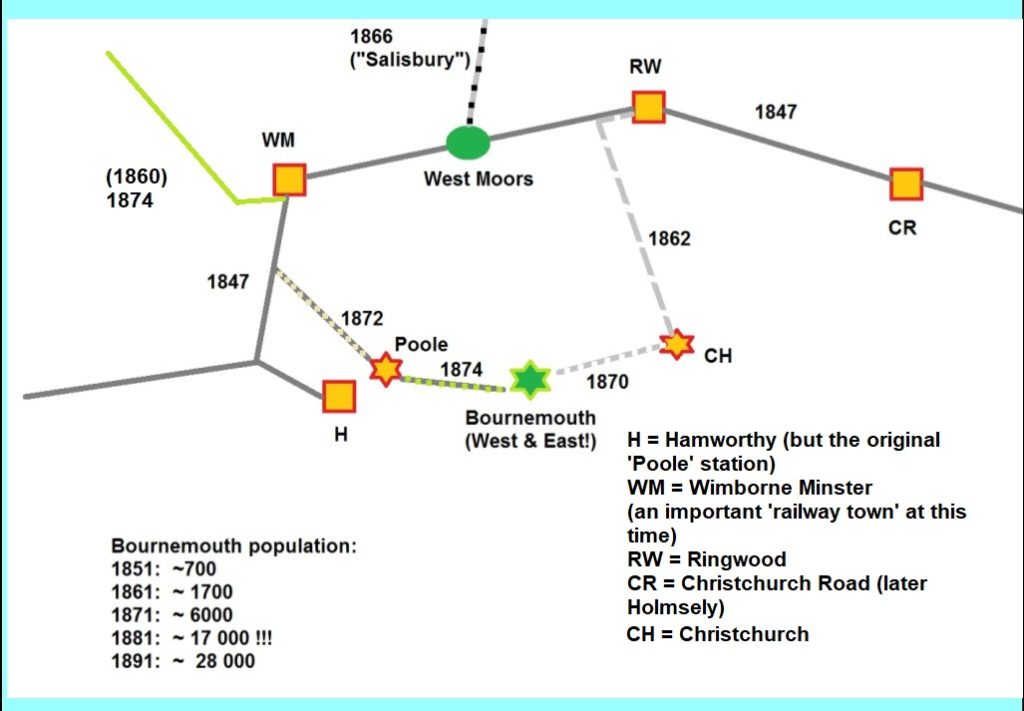
This map (below) summarises the ‘Race to Bournemouth’: look at the population figures bottom/left (indicative only of course). The real expansion of this seaside resort occurred from the early 1860s onwards; and as you can see from the dates alongside the various lines ‘as built’ (there were a few not built!), you’ll see that by 1874, Bournemouth had been well and truly connected to the railway network. “H” is now Hamworthy, but was the original Poole, but the rather more sensible location for a Poole Station arrived in 1872. This line was extended to Bournemouth (West) in 1874, but the town was actually first reached from the branch off the main line at Ringwood: this arrived, after many years, via Christchurch in 1870 at Bournemouth (East). By the way there was a scheme for a line direct from West Moors to Bournemouth (North?) to allow Great Western Railway trains to reach the south coast – this didn’t come to pass.
A TALE OF TWO SIGNALMEN …
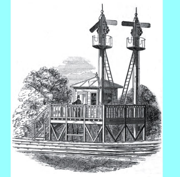
The impact of the railway upon West Moors was small until the hamlet became, in 1866, the point where the line from Salisbury joined the then main line. Before this, staff were only required at the Crossing Lodge but a junction (irrespective of whether there’s a station or not) requires additional personnel to operate the points & associated signals. Control of the ‘switch’ was rudimentary. An elevated platform was provided for the ‘pointsman’ to see the approach of the train – then he had to climb down to the ground and physically switch the blades of each point as required. In time, this developed into the familiar signal box operation once common on our railways. The staff in charge of these operations had to be trustworthy and intelligent. In rural areas, young men, who would otherwise have had to work on the land, sought employment in this role; two such were Thomas Larcombe & John Woolford; more as these posts continue … together they served the local railway through six decades.
The images show two ideas of how the junction would be controlled; the one with the locomotive is perhaps more appropriate because it shows the signals that the local railway used and the locomotive is painted in the colours of the London & SW Railway, which ran the railway when the junction was installed in 1866.
… LSWR locomotive, signal and junction control post, with policeman/pointsman in view. … although not typical of LSWR practice, this is what a junction ‘platform’ might have looked like in the middle decades of the 19th century.
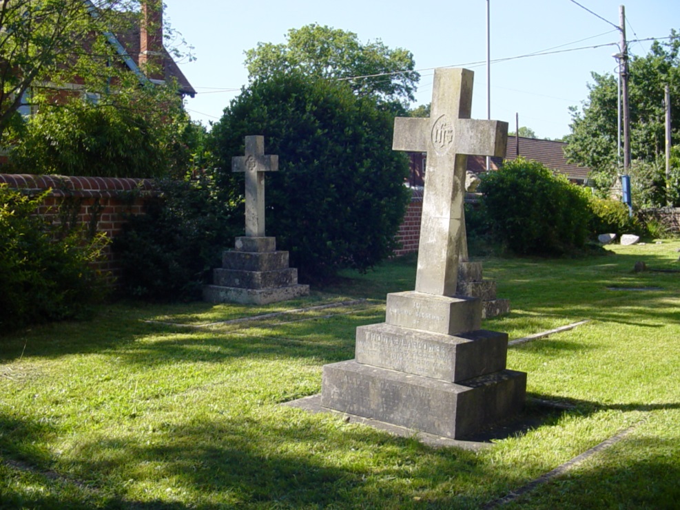
Thomas Larcombe was born near Crewkerne, Somerset. In his early twenties, he came to West Moors as a railway gatekeeper, becoming one of the ‘pointsmen’ at the newly-opened Junction in 1866. He married a girl from west Dorset who bore him 3 children; sadly his wife died at the early age of 27. Their children were taken in by other members of the family, leaving him alone. But not for long. In 1872, he married Mary Ann Woolford, a local farmer’s daughter. She was 35, which at the time would have been thought ‘advanced’ for childbearing, but she & Thomas produced three children – one of whom, Florence would later become one of the coal merchants in West Moors station yard and also the village’s first sub-postmistress! Mary Ann had an ambitious younger brother, John. He started work as a railway porter for the LSWR in Dorchester but had joined brother-in-law Thomas in the local signal-box by 1876. Thomas and John retired from faithful service early in the 20th century; they died within a year of each other; Thomas in May 1915 and John in November of the following year. As in their long working lives they ‘keep watch’ together, buried just a few yards apart in St. Mary’s churchyard. When it’s possible again, have a look at their headstones – along with other members of their families.
( There is more history about these two individuals elsewhere on this web site: see the entry ” A Tale of two signalmen ” in the menus )
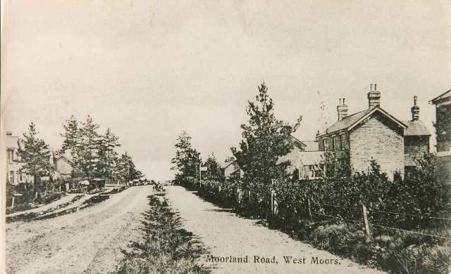
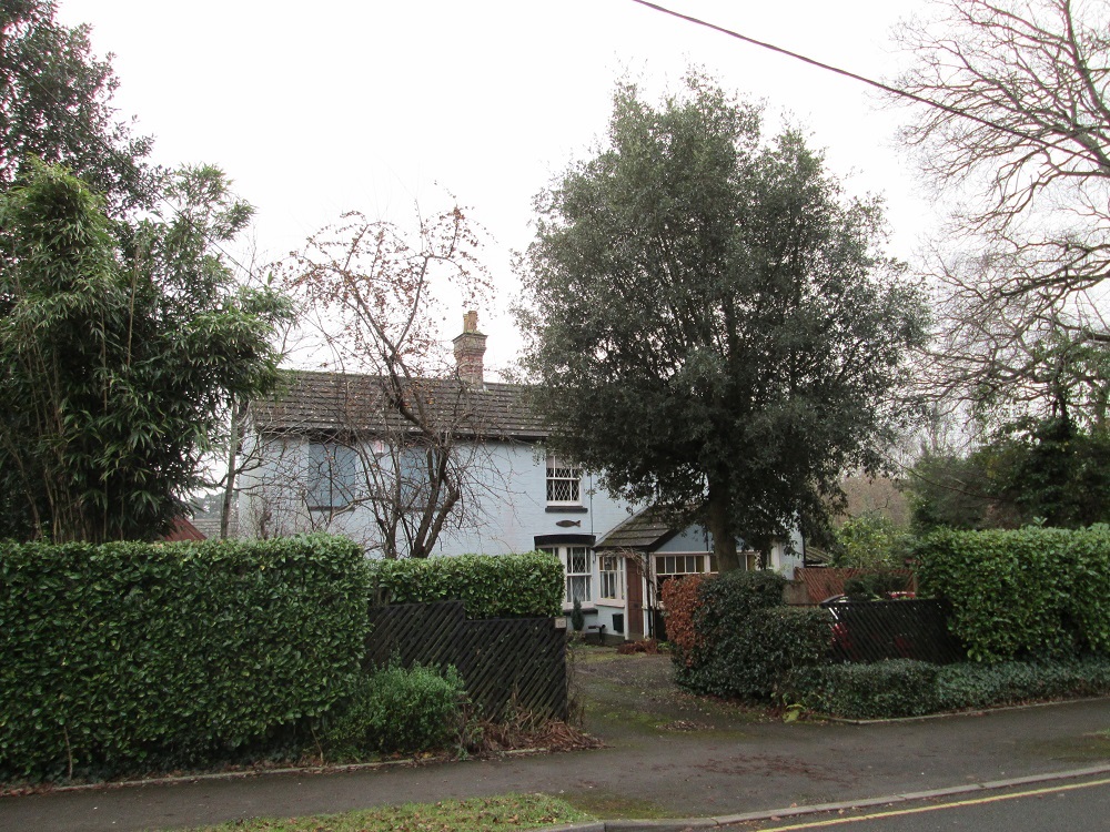
… Before coming back to railway matters (though this tale is closely allied to such), I want to write about a local heroine of mine, Florence Larcombe, the eldest daughter from Thomas’ second marriage [see previous post]. She must have been a strong, quick-witted woman – probably taking after her mother, Mary (Woolford – also see previous post) as by 1898, when she was just 23 years old, she was running a coal merchant’s business from the station yard on the opposite side of the tracks from the railway cottages where she lived with her family (see the only image we have of these below). Coal was big money in late Victorian & Edwardian times – indeed the ‘backbone’ to local railway goods operations at this time. Everyone wanted coal, not just for heating but cooking as well. I can trace at least four coal retail businesses based on West Moors Junction at this time, serving a large geographical area in this part of Dorset & nearby Hampshire; West Moors of course, but the equally fast-growing Ferndown & surrounding areas. Florence wasn’t content to rest on coal though. By 1903 she is listed as the village’s first Sub-postmistress, initially running it from No.2 Railway Cottages (a tiny property), before the family built the house which today is No.16 Moorland Road (no ‘s’ on the end of Moorland then). This was a highly responsible job. The Post Office not only transacted the usual ‘postal’ business (including savings accounts), but was the hub for postal collection / delivery for the local area (including, initially, Ferndown) with of course a close relationship to the railway. The Larcombes must have been comfortably wealthy by the time of her father’s death in 1915. Eventually the PO & coal business passed to the Nicholls family on Station Road (where the Mobility shop is currently).
Florence eventually married – one Bertie Tilsed – a tailor and passes out of our story, dying elsewhere in Dorset in 1952.
[ If this story sounds vaguely familiar, think “Lark Rise to Candleford” and Dorcus Lane! ]
The three images attached are the aforementioned only image (and a poor one at that) of the Railway Terrace / Cottages taken in the 1950s – the photographer wasn’t that interested in them! Then there is an image of Moorland Road in the very early 1900s from the Congregational Church (later URC) end, with /possibly/ a sign marking (in the distance) where the PO was, and finally a recent view of No. 16 Moorlands Road.
… extract from an image in the 1950s – with the ‘railway cottages/terrace’ highlighted.
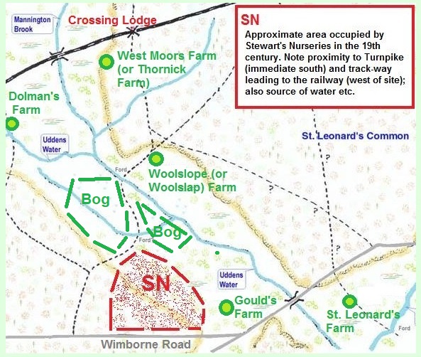
… Before moving on well into the 20th Century, I need to write something about an important part of the ‘railway’ story: the arrival & development of Stewart’s Nursery. In 1859 (railway arrived in 1847 remember), the milder climate of Dorset attracted the attention of the Stewart family: these were successful nurserymen who had, since the 18th century, developed a flourishing business in Dundee, eastern Scotland. Residential development and the presence of large landed estates across southern England provided a ready market for the products of such nurseries and the Stewarts were quick to fill the need. Two of the Stewart brothers, William and David bought a large plot of land (circa 74 acres) north of the Wimborne – Ringwood turnpike and east of what is now West Moors Road (see rough map attached), and quickly established themselves: William remained in Scotland managing that part of the enterprise, and it was the younger brother, David, who was to develop the site to its full potential. Not only was the site handy for links to local customers (especially the rapidly growing town of Bournemouth to the south), but with West Moors essentially an agricultural settlement, a source of semi-skilled and skilled labour was readily available. And by this time, youngsters of families attracted by the arrival of the railway were also available for employment in the Nursery. The land straddles two basic soil types: poorer, heathland soils and the rather richer, though boggier, land astride the Uddens. Stewarts were eventually to utilise the availability of the latter feature (labelled ‘Bog’ in the attached sketch-map) and became renowned growers and sellers of aquatic plants across England – water lilies being a speciality by the early decade of the 20th century. Given the already high reputation of Stewarts, it was natural that orders for plants would come from further afield than the immediate area of Dorset and SW Hampshire and the adjacent access to the rapidly growing railway network provided the means to fulfil these orders. I suspect, though can’t provide documentary evidence, that the goods traffic generated tipped the balance towards the provision of a fully-functioning station in 1867. By 1915, Stewarts were one of the largest plant suppliers in Britain (and a large employer locally); the goods revenue for the railway must have been very welcome. The firm provided the ‘northern’ focus for the growing town of ‘Fern Down’ (later Ferndown) and until the 1920s, the centre-of-gravity for this settlement was along the Wimborne Road and immediately north and south of it – explaining why there is a centre separate from the modern town in this area: the telephone exchange, post office, chapel etc., were all located here – some way north of the modern town centre, which latter has Victoria Road & the Poole-Ringwood road as its focus. Stewarts were using the railway until long into the twentieth century but the greater flexibility of road transport, and the improvement of the road network eventually removed the need for local access to the railway and for this and other commercial reasons, Stewarts relocated away from Ferndown in the latter part of the 1950s; the Stewart story continued of course – have a look at their web site … https://stewarts.co.uk/about-us/history/
… just a little addendum to the last railway / local history post before carrying on: I mentioned regarding Stewart’s Nursery that they could draw on local people to work in the Nursery. Whether directly connected to their activities or not I can’t tell, but by the end of the 19th century, the West Moors community was a little ‘hot bed’ of agricultural / horticultural enterprises. For example, based on the 1901 census return, 14 ‘farms’ are listed in that return and no fewer than 9 ‘Market Garden’ operations – all within the area that would be currently defined by the civil parish of WM. Not necessarily a large employment source though – just 45 connected with the land in 1901, but rising to 113 ten years later. But of course this must be set against quite a small population – around 250 in 1901 (includes children), rising to 650-ish by 1911. All these growers/farmers would use the railway both to export produce (apart from purely local sale) and also import equipment, fertilisers etc., the same way – there was no practical alternative – at least until the 1920s. This is reflected in the numbers attributed to the L&SWR payroll at West Moors … 19: a ‘typical’ country railway station staffing level around this time would be 10 or less.
… back to railway history: about time we had a locomotive! This image is turn of the 19th/20th centuries: it neatly demonstrates how far railway motive power had come in the 70 or so years since those early days – a typical view for a main-line working around this time on the lines running through West Moors Junction. The footplate crew have much more protection – not fully enclosed but better than as recently as the 1870s. The overall design of the engine is elegant with clean lines and a lot of the ‘motion’ that drives the loco hidden from view. The early Edwardian era for locomotive design was probably the peak of efficiency of use of coal and water – until the advent of designs seen in the 1930s. Further back, the carriages are much more comfortable to ride in: bogied wheel sets i.e., the wheels not bolted directly onto the carriage, but carried on the bogie sets which can turn on the curves. The suspension much better; some corridor sets being introduced, and on some services (but NOT universal) on-board lavatory units – though it has to be said that these discharged /directly/ onto the track – a hazard to the permanent way gangs & station staffs until very recently. Hence the ‘do not use in station’ notices! This time was the height of railway use in this country – both for passengers and freight; the railways were part of the community and background to daily life in the way that the internet is to us today.
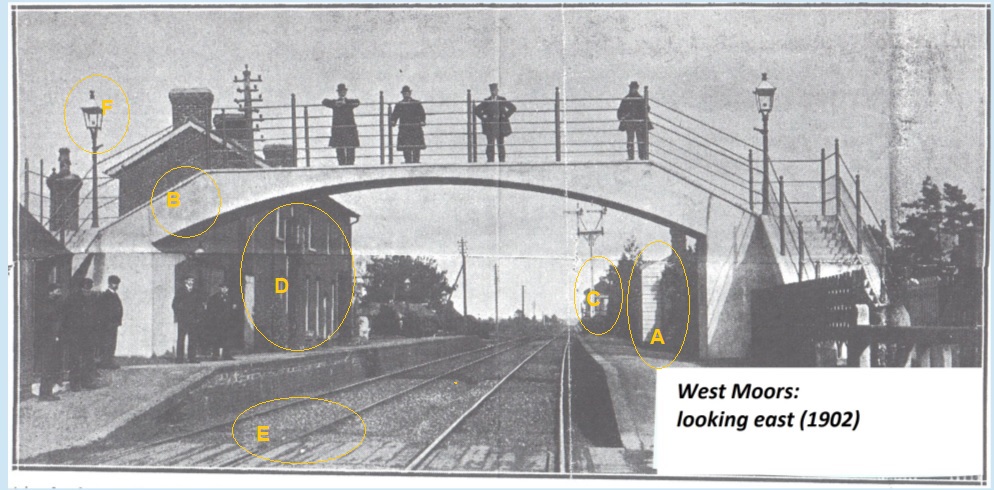
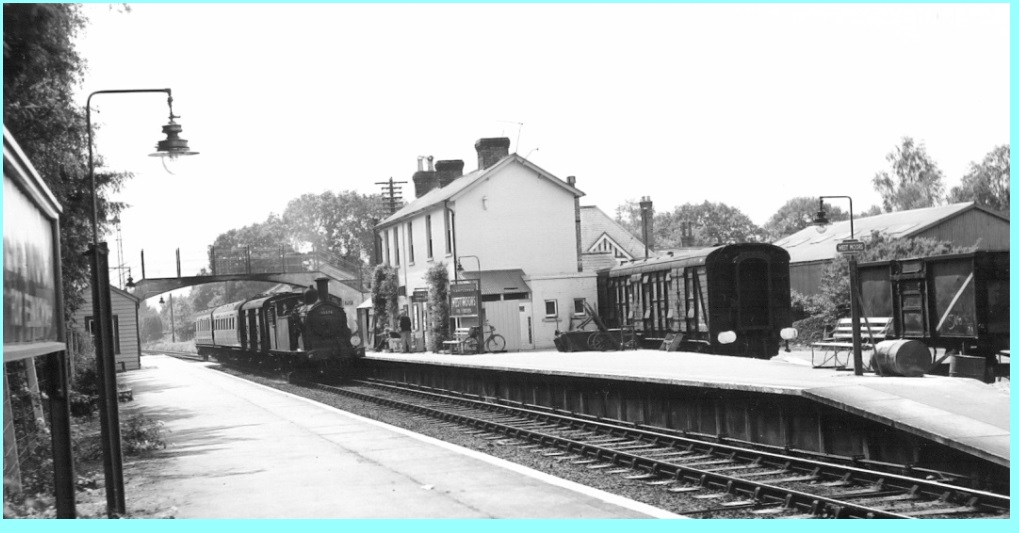
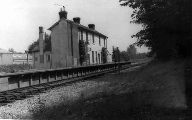
… The next posts will deal with a fascinating (to me) photograph published in a newspaper just before the Second World War. It was taken for the opening of the footbridge over the railway tracks at West Moors in 1902. I’ll write more about the various bits and pieces in the image later ….. but for now I’ll try and detail who is in the image as listed in the accompanying article: they may be your ancestors!
On the footbridge: from left-to-right: Mr. J. Baines, permanent way superintendent, Ringwood; Mr. James Hutchings, permanent way inspector, Wimborne; Mr. H. Martin, stationmaster, West Moors (note the splendid cap) and Mr. G. Wilcox, ganger, West Moors: the latter name will be familiar to anyone who has read “West Moors for Ferndown” as George Wilcox, who lived just off Ashurst Road, behind the railway yard & was part of a large family steeped in railway operation at this time. Henry Martin was SM for the first few years of the new century and oversaw some major changes (footbridge, move of signalbox, increased passenger traffic etc.)
I’ll write more about all that later: from the article in the newspaper, other names that could be remembered are:
On the platform … Pat O’Neill and Jack Hazzard, gatemen and porters (who would lose their jobs in a couple of years – at least as gatemen); J. Peatling (or J. Dolman), Mr. Grist, clerk and ticket collector; F. Wilcox [ another Wilcox! ], coalman. Others are Mr. F. Merritt, a guard and Mr. Dibsdale, son of a blacksmith from Ringwood. Also identified was G. Sansom – another name from the “West Moors for Ferndown” saga!
The opening of the concrete/reinforced footbridge was a great event for West Moors …. and a pivotal event for the London & SW Railway (and later Southern Railway). More anon……
… I’ll split up the text across two posts … but the same image will be shown … letters refer to the highlighted bits of the photograph.
Working in chronological order …
A: is the 1898 ‘Waiting cabin’ on the ‘down’ platform, i.e., travelling towards Wimborne, Poole and Bournemouth. It was installed, complete with small fireplace, for the increased number of passengers once the village had started growing in the latter part of the 1890s. Nothing was needed before, as most of the very few ‘customers’ travelled to Salisbury, Southampton & Waterloo – so waited on the ‘main’, or ‘up’ platform (D): mind you, there wasn’t much shelter there either – except within the station house itself. This demonstrates just how little passenger traffic there was. There never was a canopy over the platform as the 1867 station was built as a goods handling structure.
Once the ‘great and the good’ started to build/occupy their substantial houses in The Avenue, Woodside Road, Denewood Road, Highfield Rd, Moorland Rd, Glenwood Rd etc., they prevailed upon West Parley Parish Council to complain to the L&SWR regarding being held up at the crossing when wanting to cross, either from the ‘north’ to the newly built shops lower down Station Road or from the ‘south’ to the newly-built church and the ‘parish room’ (otherwise known as the Iron Room).
Not only that, but the only method of crossing the tracks was by means of the ‘on the level’ baggage trolley crossing (E). In 1902, the railway erected this magnificent footbridge (B). It was a German/French design, but built on site here (just south of Mary Lane I think), using techniques of reinforced concrete, then quite novel in this country. Formerly, such bridges were either wooden, or cast-iron (with or without brick piers) and there was much fear that the concrete structure would fall down! However, it lasted until the early 1970s, when it was demolished: it would probably be Grade II listed now given its importance!
More on this photograph next time ….
( see text for significance of the letters )
… Continuing with the same image (repeated here) as shown in the last post ….
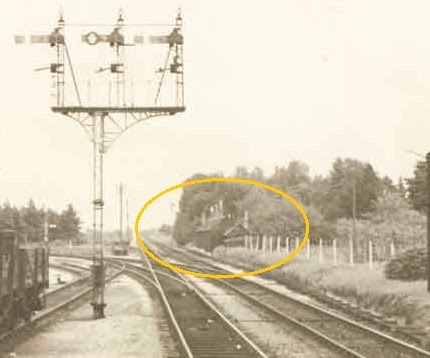
C: is the 1870s signal box, opposite the junction, with adjacent two-arm signal. For railway aficionados, the fact that the arms are /level/, that is one isn’t higher than the other, shows that the lines diverging here had equal status – indeed /both/ lines had main-line traffic – you could get to London either via Southampton or via Salisbury. In 1904 (after this photograph), a new signal box was built on the ‘up’ platform (roughly where the group of men are standing extreme left), so that the signalman could control the crossing, rather than having a couple of gate-keepers or relying on the station staff to open the gates; however, this had a ‘down side’ as well. When there was someone manning the gate, he could ‘allow’ someone to nip quickly across as he closed the gates – knowing whether a train was coming. When the signalman controlled the gates, he /had/ to close-off the gate before setting signals, handing over / enabling tokens etc., and this led to extra delay for road users trying to cross the railway. And this frustration lasted until the railway closure.
F: note the lamps; these were oil lamps, a fiddly operation to clean, fill and light, and it must have been a blessing when gas arrived in West Moors in 1911 and the station lamps were converted.
When this photograph was taken, the nation’s railways were at the pinnacle of their importance to the day-to-day life of the village: it would remain thus until the advent of road transport ‘in bulk’ just after the First World War … which I hope to cover in a little while.
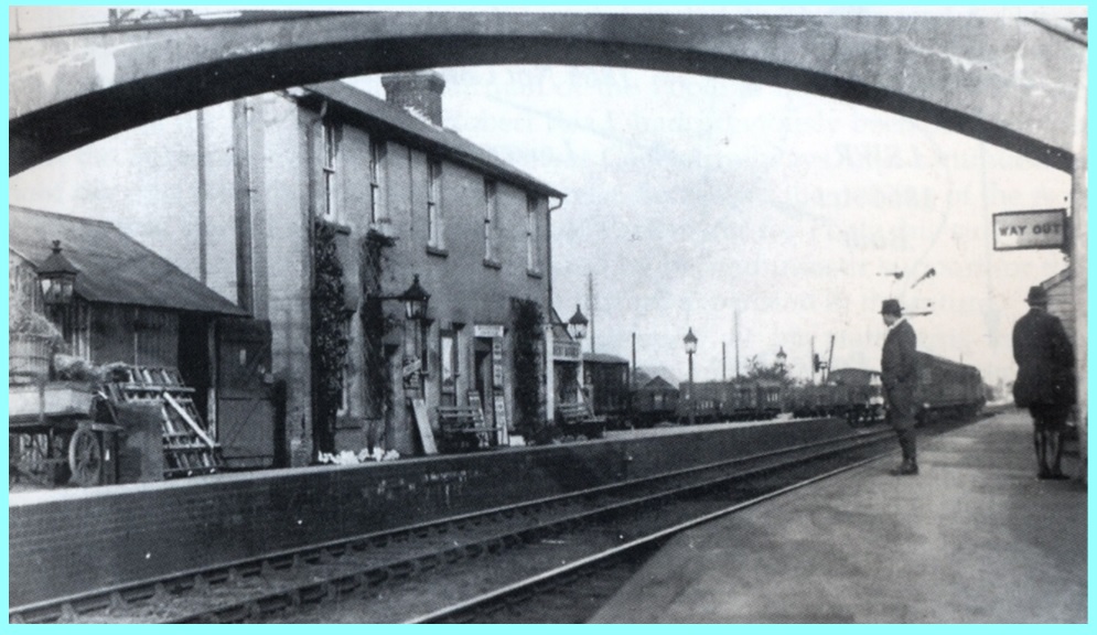
… OK then: three images coming up – one more at the station, then a couple from early West Moors Station Road (or Ferndown Road); more about those as they come along.
The image here is of West Moors Junction ‘between the Wars’. Difficult to date exactly, but from several clues in the image, and comparing it with similar shots where we /do/ have an idea of the date, I’d place it somewhere in the mid/latter 1920s. Lamps lit by gas now – plenty of goods wagons of /all/ sorts [ i.e., not just coal ] in the siding and lots of ‘loose packet’ freight waiting to be sorted on the ‘up’ platform, some offloaded from the train which is heading off towards Ringwood and Brockenhurst (right-hand signal is ‘off’). Where it is possible to read the letters on the wagons, it looks as if the nearest one has “S” “R” painted on. The Southern Railway didn’t come into existence until ‘Grouping’ in 1923, and it would have taken a couple of years at least for such wagons to be re-painted (from LSWR), so again it looks to be well into the 1920s from this argument. Note the signal post has switched sides when compared with that of the footbridge shown earlier. The sign says “West Moors “, not “West Moors for Ferndown” which places it before the mid-1930s, yet the footbridge has plenty of smoke-staining so obviously been in use for many years. The two gentlemen waiting on the ‘down’ (Wimborne, Poole, Bournemouth) platform are sturdy, solid chaps with good workaday boots – are they off to Wimborne for the market?
All-in-all, a typical country railway station of the period.
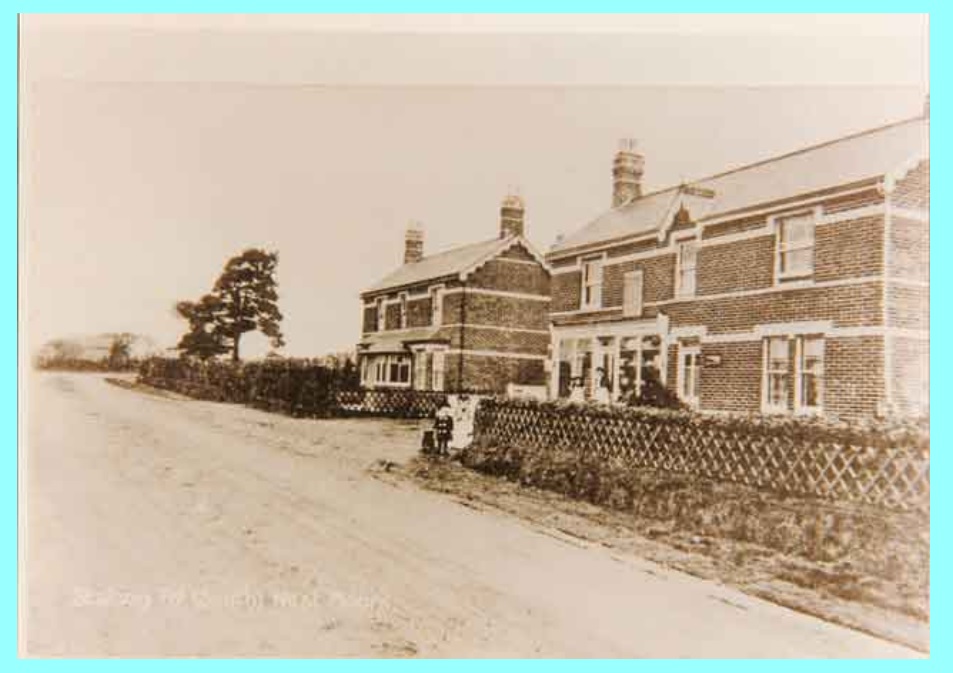
… this view isn’t quite the earliest of this part of Station Road [ annotated on some photographs as ‘Ferndown Road’ ] but does give a decent idea of what the first ‘new’ buildings would have looked like in the first decade of the 20th Century. I judge the date to be in the range 1906-1910 (but the buildings originate from circa 1900/1901); out of site behind the further house would be the original Congregational Chapel (now subsumed within the URC of St.Martin’s). Just visible beyond the two trees is the turning for the new [Brewer] development of Moorland(s) Road. The track leading to ‘West Moors Farm’ (as it would be known at this time) is out of sight opposite this turning. The two houses are obviously built by the same builder – the /further/ one is still with us – it was Dr. McKinstry’s surgery, now part of West Moors Medical Practice. The nearer house / grocery shop is run at this time by the Stickland family. Walter Stickland married Mary Frampton in 1898: Mary was the youngest daughter of George Frampton & Ann Ware, who ran the /original/ grocery-cum-nursery further north on Station Road (north of the modern ‘cut-through’ to Fryer Field). The Stickland clan had establised a thriving grocery businesses in Three Cross – Walter would go on to be a pillar of local society, Parish Clerk (of West Parley), Churchwarden, and enthusiastic photographer! This latter building is no longer with us – the footings are now under Bramble Court. I’ve got other views of these buildings which may appear in the future – depending how long all this ‘lock-down’ goes on for!
… the last in this series of old photographs : if the present problems persist I may put some more up from another presentation later.
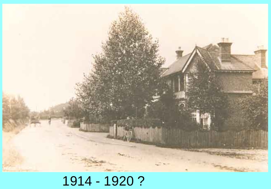
This view is of Station Road, looking north, from a point roughly at the modern crossing of Station Road, Park Way & Pennington Road. Date sometime immediately after the Great War: my source gives the figures on the photograph which seem reasonable – I’d go towards the ‘1920’ end of the range, based on clues in the image.
The nearest building is, you might be surprised to know, still there! The core is now part of the block that contains Station Hair, Seafoods & Kiteleys. The most recognisable bit is the ornate early 20th century chimney stack – which used to be at the end of the building, but with the extension is now incongruously a third of a way in! Incidentally, the adjacent building housing 3 Wishes etc., is also an early 20th century original … all built before 1910 and part of the ‘new heart’ of West Moors once the Brewer Brothers initiated development discussed elsewhere. Note the horse & trap and bicycles … still very much a country village of the old style. Nothing built to the left of the view … they come with the Baker developments in the latter 1920s.
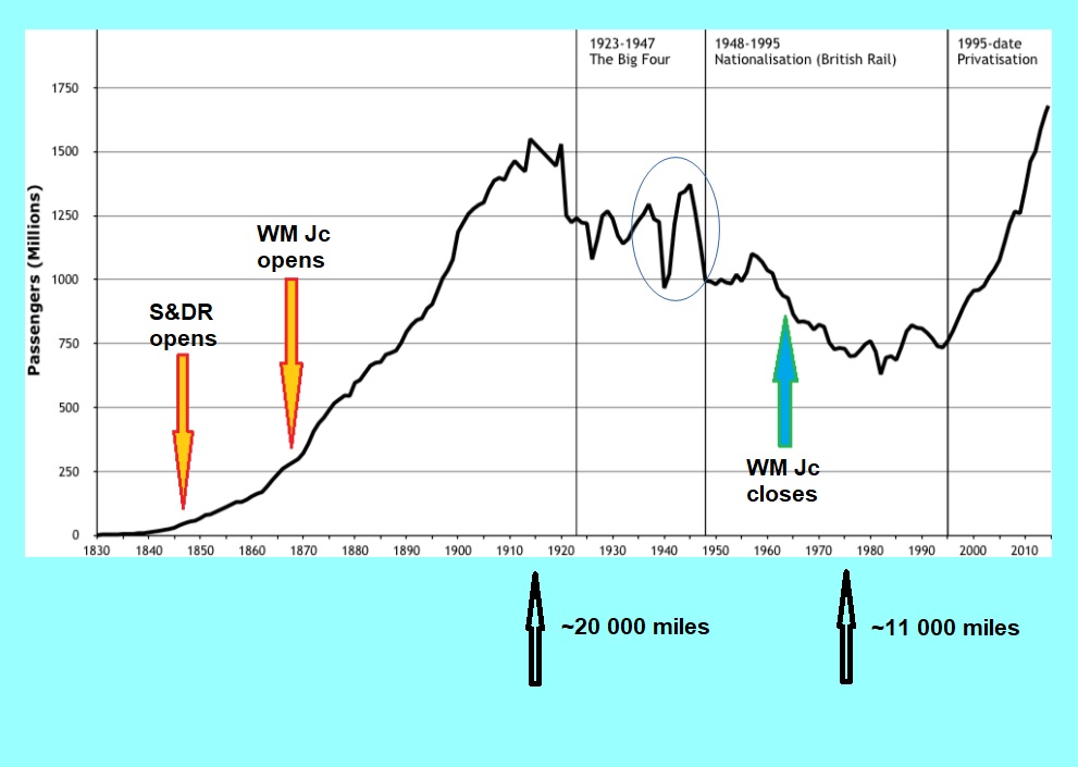
… Moving on after the Great War, and the railways, both nationally and locally found that the transport ‘landscape’ was changing fast. Local councils were beginning to upgrade the road network as more people used them through use of cars, buses, bicycles and so on. Much as today, demand led supply, which generated demand. By the 1930s, railway (passenger) travel had declined significantly. This was the era of the ‘Shell Guides’, expansion of the AA and RAC, the building of more roadside petrol stations/garages. The graph attached shows the rise and fall of railway passenger journeys – a peak in the pre-Great War era, drop post-war (some due to post-war recession), then the irregular use at a lower level in the 20s and 30s. The national railway network would never reach the dizzy heights of the summer of 1914, until that is modern times!
Goods traffic though a somewhat different picture: railways still bore the brunt of ‘heavy lifting’ of freight traffic – except for local work. Coal was the ‘bread and butter’ traffic for places like West Moors, but unless you were moving goods, large or small, more than a dozen miles, then the railway network was the only practical alternative. Only in the Fifties did long-distance lorry transport start to seriously eat into railway goods work.
Britain’s railways were saddled with the ‘common carrier’ obligation until the 1960s by the way; they had to accept whatever goods traffic was offered to them – at controlled rates – unlike road hauliers who could pick and choose what to carry. This would be a significant factor in the demise of local stations with goods sidings and the ‘pick up goods’ train such as called at West Moors.
[ The two figures at the base of the graph are the length of the British railway network in miles at those years. The graph at the right-hand end should also poke up even more – until a couple of months ago of course! ]
I’ll have a look specifically at local buses next post …
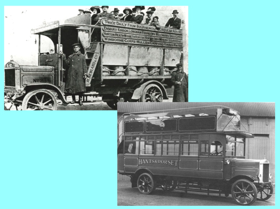
… Not sure when the first bus service arrived in West Moors: reading the various histories, it’s a toss-up between just before 1914, or in 1919. At the moment, I’m inclined to the earlier date – but just twice a week at first, increasing to a daily (once or twice a day) service after the War. Locals at first would not have felt a great need of buses – as most were within walking distance of the Station (and a good train service). However, as the village expanded in the post Great War era, plus of course Ferndown was expanding (rapidly) not far away, the bus would provide a local link to/from the Station, as well as connecting with Bournemouth. Bus usage expanded dramatically in the early 1920s, particularly as the terminus in Bournemouth was closer to the main shops than either of the railway stations.
The two vehicles shown here demonstrate what was available. The first is a ‘Straker’ (perhaps converted lorry) of H. Newland & Co, Stewart Road, Bournemouth. It explicitly lists “West Moors” on the side-board, along with many villages hereabouts (as well as Wimborne). Note that it is ‘dual purpose’: milk below, passengers above! The ladies especially would not relish the steep climb up those steps. No shelter for passengers (the milk churns fare better!) and precious little for the conductor and driver! Things have improved by the first few years of the 1920s, when Hants & Dorset run many services round here – they were originally Bournemouth & District Motor Services, changing name in 1920: the second image shows what I think is a Leyland bus with better protection for all – still open on top though – and with solid, unforgiving tyres, but with the curved staircase at the rear a bit easier to navigate. The modern-day Morebus can trace its history (complicated though it is) back to these Hants and Dorset days.
… nearing the end of this canter through some of my presentations: I wanted to cover a topic close to my heart – an historical event that involves West Moors, but I suspect many, if not most people living here now haven’t got much idea of its importance.
I’ll take a few posts to do it justice ….
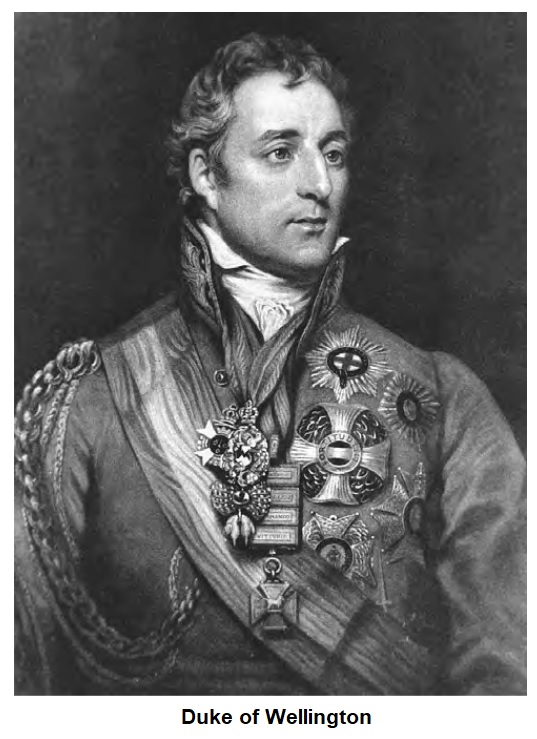
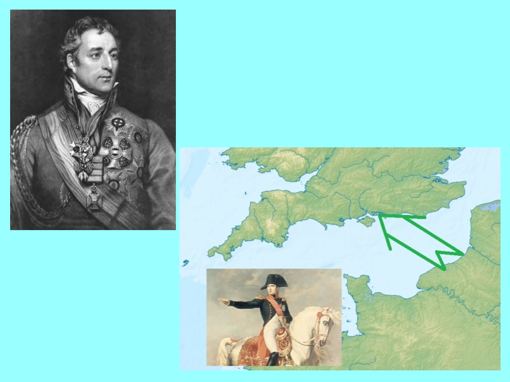
What, you may ask, has His Grace the Duke of Wellington got to do with the story of West Moors, its railway and the Second World War? Bear with me!
The ‘Iron Duke’ was no lover of railways – if you want to see why, see my web site page dealing with “the railway goes to war”. Suffice to write that he was lauded as the “Victor at Waterloo” [ the Prussians helped ] and he had held high political office, including two spells as prime minister, by the 1840s; although he was towards the end of his long and eventful life, his opinions carried great weight.
When Castleman, representing the local backers of the S&DR was navigating the parliamentary minefield of getting the enabling Bill through its legislative process, there was considerable opposition from the New Forest Commissioners. At first, they objected to the railway coming /anywhere/ in the Forest; when that became an untenable position, they fought to drive the route as far south as possible. One plan I’ve seen would have seen the line sweep much further south that it was originally built – nearer Lymington than Brockenhurst … and ironically close to the modern-day main line through Christchurch, Bournemouth & Poole.
However, this was, at the time, out of the question: Ringwood & Wimborne would have had to be served by branches – hardly what the backers envisaged. West Moors would have been left alone! The Duke of Wellington, ever the master military tactician, argued that a line well away from the coast would be much more useful should those naughty French invade …. more next post.
… so, why worry about the French? Though they were soundly defeated in the continental wars and on the High Seas, they were still a threat. Wherever the British Empire spread its fingers, the French were sure to be next door! Indo-China, North America, the Pacific archipelagos and of course, Africa.
And they were brooding, just the other side of the English Channel. Although Wellington was ill-disposed to railways in general, their usefulness in moving troops to counter any French invasion got his whole-hearted support. Napoleon might have long left the field of battle, but other French tyrants might arise … and ‘revolution’ was also in the air across ‘La Manche’. By 1848, just one year after the Southampton & Dorchester had opened, the “Peoples’ Revolutions” had threatened the stability of continental Europe in much the same way as the French Revolution & the rise of Napoleon had half-a-century before.
As it turned out, the railway was not called upon to fulfil the task of saving England – at least not yet. It would be used in the Great War to transport men and supplies to training grounds & embarkation ports in that conflict … and in the early phases of the Second World War, its defensive potential saw movement of munitions, rail-mounted artillery etc., to the south coast … but it was never called upon to support the rapid deployment of defensive troops as envisaged by the Iron Duke – but a new ‘Napoleon’ did arise and disrupt the peace of Europe – not from France, but from a united Germany.
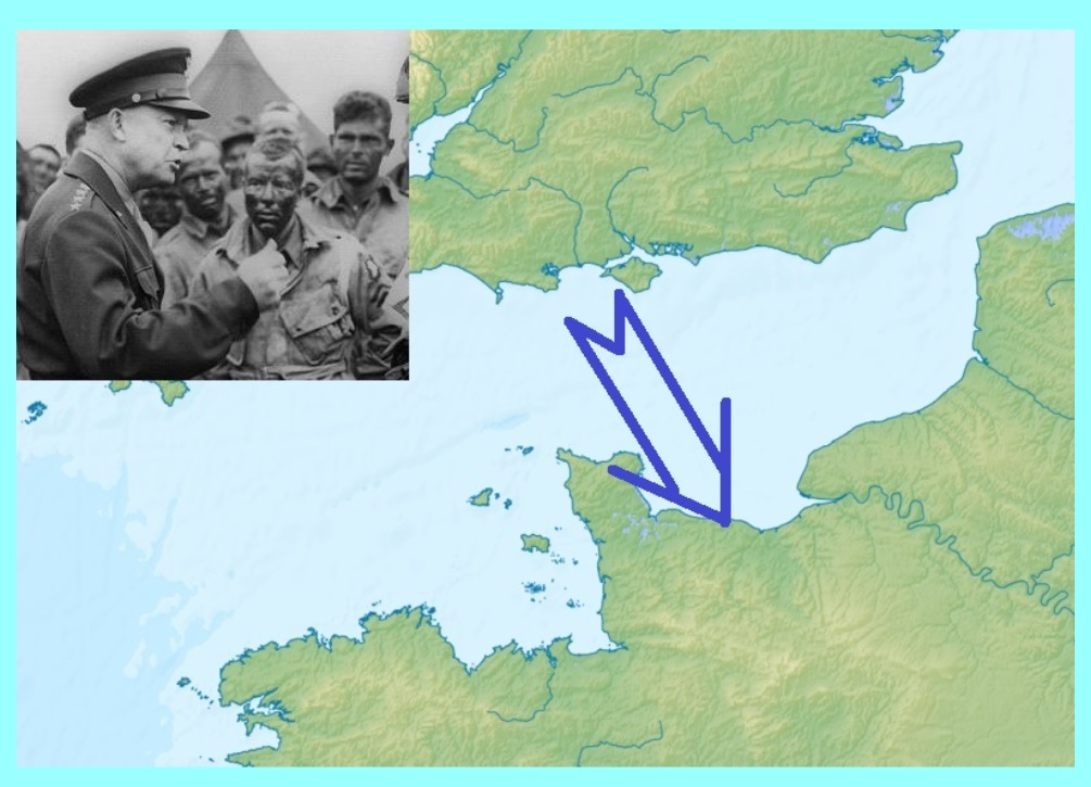
… What could not have been foreseen in the 19th century was that an invasion in the ‘reverse’ direction to that feared then would be required. When Churchill met Roosevelt in Casablanca in early 1943, the final ‘war aims’ were agreed – one of which was that ‘maximum effort’ was to be deployed on launching a seaborne assault on the north coast of France. Events moved swiftly once the political decision was taken. Among other matters, fuel-oil (petrol, diesel) and lubricants would be required in enormous quantities. Work proceeded swiftly to convert the existing W.D. formation that had been installed at West Moors into a major fuel depot – one of several – complete with an extensive network of railway sidings, linked off the main line just east of the junction with the Salisbury line. The scene was set … more as we go on …. it’s a fascinating story ….
… West Moors was in an ideal location for the fuel depot: of all the six ‘forward’ units spread out across the south of England, it was by far the largest at 1.5 million gallons – holding a *third* of all the fuel needed for D-Day surface-invasion operations (Overlord) and a fifth of ALL the UK allied base petroleum – oil – lubricant (POL) capacity.
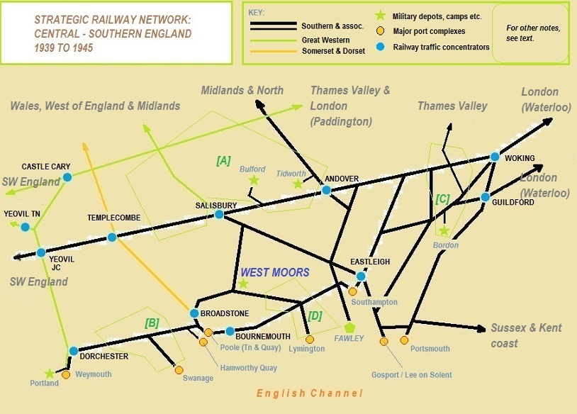
Have a look at the attached schematic diagram …. it shows the broad layout of the railway network between 1939 and 1945 across this part of southern England – the major concentration of military activity is shown (but NOT meant to be exhaustive).
The railways were to play an important part in the build-up and execution of the invasion of occupied France. They had already endured over 3 years of war, with maintenance of motive power, rolling stock and infrastructure pared back to essentials – now they had to step up and move vast quantities of men and war materiel, as well as the background ‘normal’ traffic of day-to-day life. And all this under attack from German air force raids. By route mile, the Southern Railway was by far the most impacted by these attacks – for obvious geographical reasons.
The scene was set for the greatest amphibious assault operation in history: if it had failed, the history of Europe and the World would have been greatly different – the railways played an integral part in the plan ….. more to come ….
[ Notes to the diagram: most is self-explanatory, but the key for the ‘area’ are:
[A]: Salisbury Plain training and barracks areas / ranges – also some RAF airfields.
[B]: South Dorset tank training & testing areas: also basing locations later in the war.
[C]: North Hampshire/NW Surrey training, barracks & testing area/ranges.
[D]: New Forest/SW Hampshire training and basing areas. ]
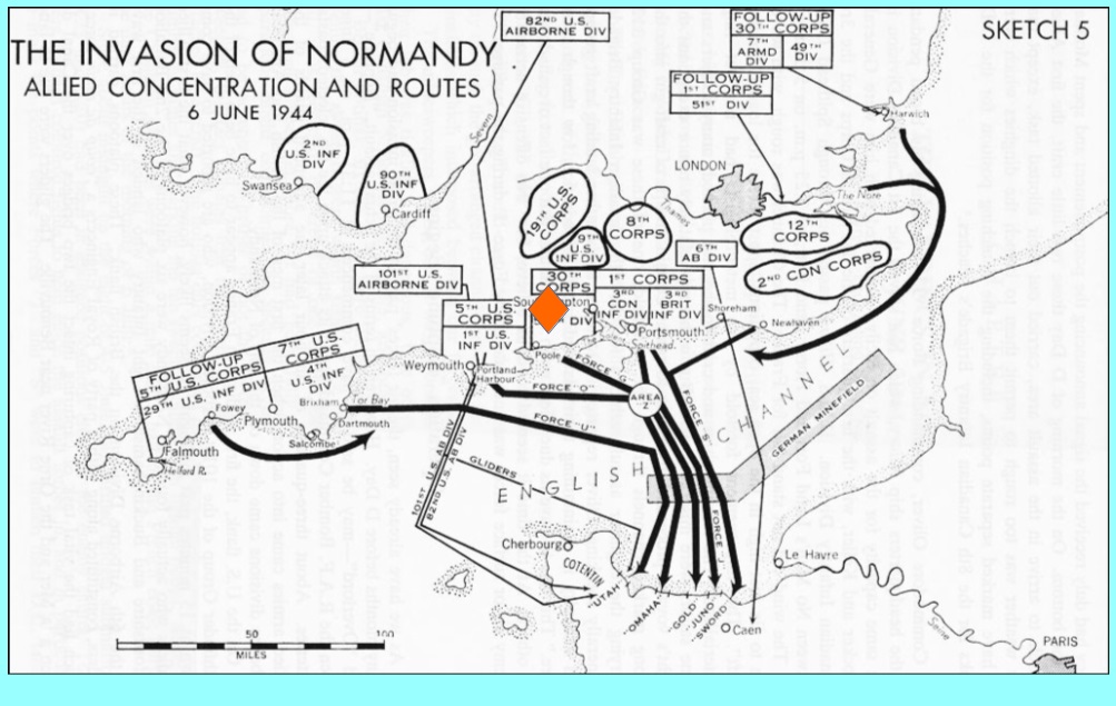
… The orange lozenge on the map attached marks West Moors – location of one of the six ‘forward’ fuel supply depots for “Overlord”; they were spread out from south Devon in the west to the South Downs in the east.
As noted before, West Moors (US Army unit Q-328) was by far the largest – and now that you see it plotted against the invasion routes, you can see why. The German High Command would have loved to know where this concentration of supply was; von Rundstedt & Rommel were professional soldiers who would have seen immediately that the invasion must be targetted on Normandy, /not/ the Pas de Calais (as they thought even immediately after the 6th June invasion). If the West Moors facility had failed – the entire operation would have failed.
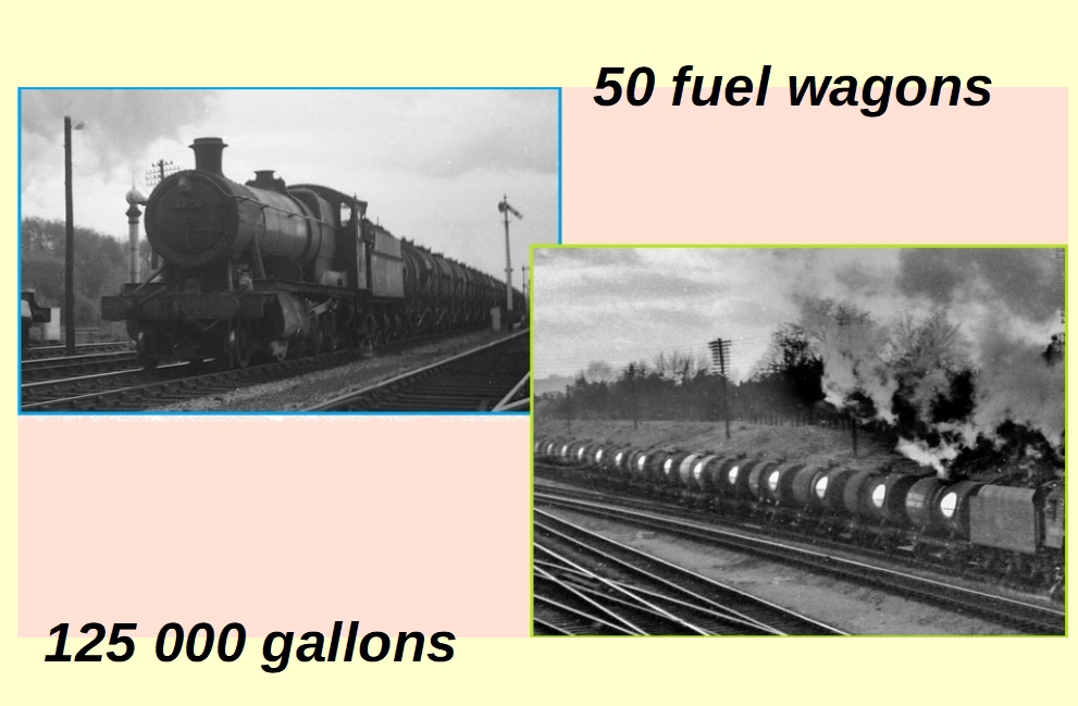
All the depots were fed off adjacent main-line railway feeders – the second image here is NOT of wartime operations: anyone taking photographs of military activity in southern England at this time would have not survived at liberty for long! However, the photographs do illustrate well the activity that our local railway would have experienced from summer 1943 until August 1944.
When at ‘full tilt’ each train-load would have consisted of some 50 wagons, with a total capacity of around 125000 gallons. To try and put some ‘scale’ on this, it’s roughly the equivalent of drawing 14 average-size supermarket filling stations behind the locomotive!
Nerves required by train crew: a hot engine at the front – spewing hot ash and glowing embers from the chimney, dropping ash from the firebox, the constant threat of running hot axles, on track under-maintained due to wartime restrictions … and enemy air attack! And all this twice per day.
… So, how did it all work? The attached schematic shows a rough idea of what happened …. each of the six fuel depots were fed from the railway as already described: the train would draw into the depot – either parking the wagons in a siding, or, as in West Moors case, using a berthing loop off the main line to avoid blocking the running lines for too long. Even so, it must have taken a lot of careful shunting to manoeuvre the very long train to the correct position – particularly at night – and again in the case of West Moors, the /distant/ entry-point for the loop was too far for the Junction signalman to see/control – it was ‘released’ electrically from the Box and then it was up to the staff out of sight to control movements correctly. Which of course they did. Once the train-load had been parked, the locomotive would then have to collect the ’empties’ and carefully get them back onto the main line and away to the refinery. By the way, there were no ‘bulk storage’ tanks here: the storage /was/ the wagons.
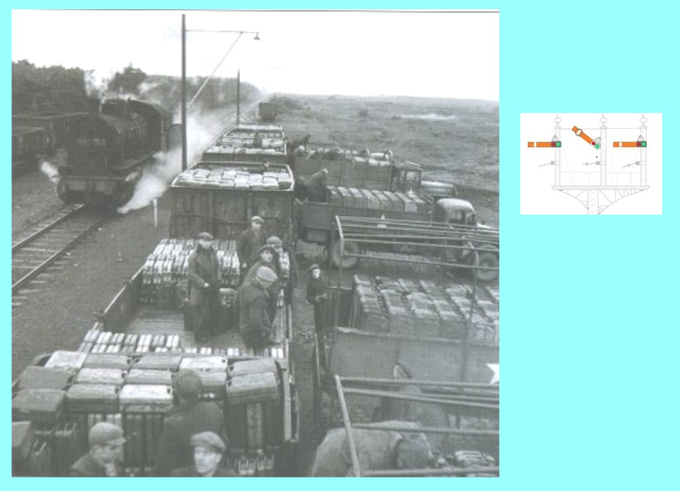
The US Army personnel would then take over and using shunting locomotives they’d brought over for the purpose, split the rake of wagons up according to need and what the wagons contained.
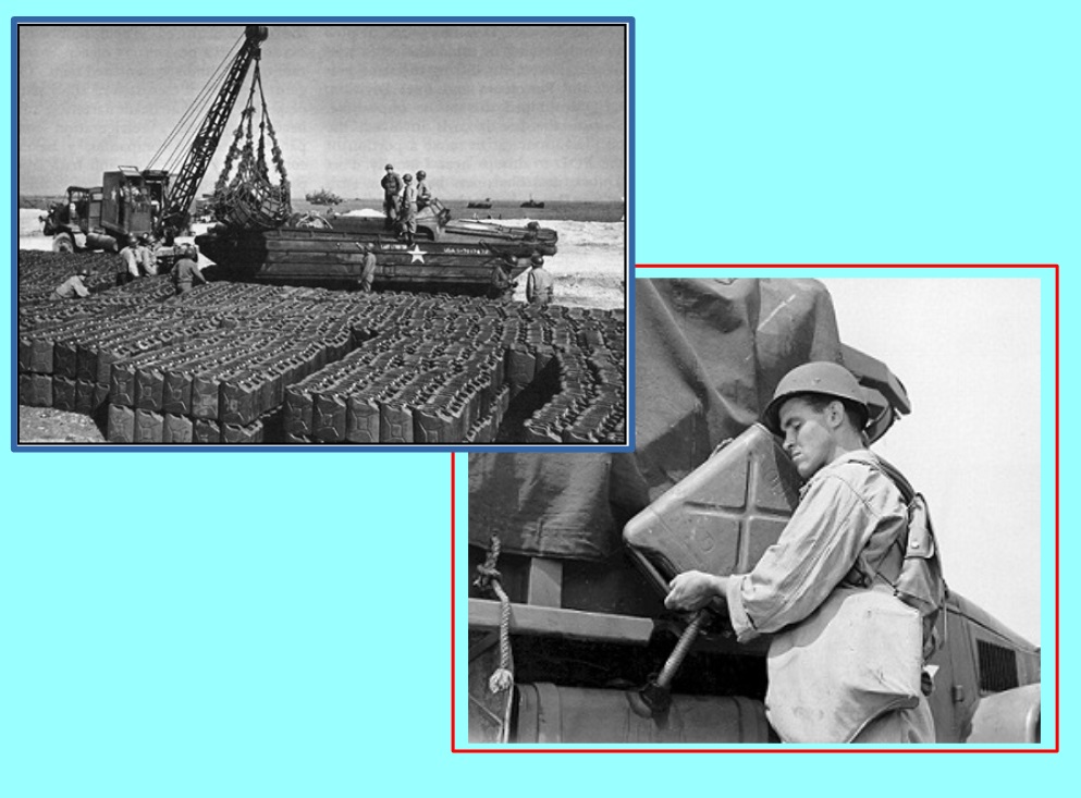
Then came the arduous task of decanting the contents of the wagons into the 5 (US) gallon jerrycans that can be seen in the second photograph. Civilian contract workers performed this task – and also drove the lorries around the country to their ‘drop off’ points …. essentially roadside fuel stations of stacks of fuel cans/oil drums ready for individual units to drive-by and take their fill.
This wasn’t just a May/early June 1944 operation; the depot had been opened in February 1943, and steadily worked up to provide support for the growing assembly of troops through summer and autumn of 1943, with increasingly intense exercises winter ’43/’44, culminating in ‘dummy’ invasion dress rehearsals from April 1944.
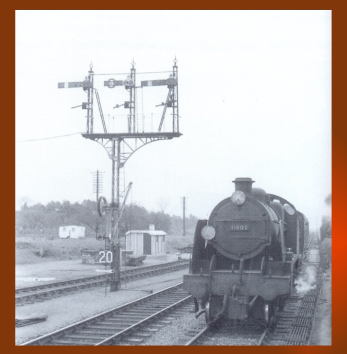
Why the signal gantry? It’s the iconic symbol of West Moors contribution to Operation Overlord – the central semaphore arm (with the round open disk) being the signal which controlled access to the fuel depot.
… and of course, we know now that the entire operation was a success … the men, in and out of uniform ( US Army, civilian driver/loaders & railwaymen ), working the fuel depots did their stuff as required – perhaps not knowing just how important all that work was.
Although a US Army operation (and they seem to have all the photographs!), it was on behalf of the Allied Forces of all nationalities.
The system of supplying fuel to operations in France continued through successive waves of troop ‘insertions’ from the English shore – until the famous ‘Mulberry’ harbours could be put in place and fuel taken direct to the land forces in Theatre; later still, the harbours of Normandy were brought back into operation after the damage due to both invasion & sabotage was repaired. The need for supply of fuel from the southern English depots gradually dwindled, and the local Depot was effectively shut down in August 1944.
It’s a small piece of the history of the Second World War, but an important one; if the supply of fuel had faltered or failed, the whole ‘timeline’ of operations would have been knocked out of shape. We should remember the place that West Moors and its railway played at this critical time in the nation’s (and European) history.
… the War ends … and this romp through some of my presentation slides is coming to an end soon: after 1945, the railways, so important in support of the Allied cause for 6 gruelling years, were worn out.
Lack of substantive maintenance, shortage of money in the economy, disinterest of the travelling public (once the immediate post-war euphoric rush to the newly opened coastal resorts was over), and the paralysis engendered by the election of the Labour government in 1945, with its plans for Nationalisation, all contributed to an industry in the doldrums.
1948 and the vast majority of Britain’s railways come into direct public ownership. Whether that was the right thing to do – whole reams of paper have been used to argue the pros and cons. In my view, it was probably inevitable simply because the commercial companies wouldn’t have been able to find the finance to fund the drastic upgrading of the network required …. but then neither did the Labour government – probably an impossible task!
The second image is typical of West Moors in the 1950s and early 1960s: a push/pull service about to run into the station, before heading off again to Ringwood and Brockenhurst. Count the people on the platform … spot the goods packages on the platform … you’ll not have to waste much time on the task … traffic in this post-war period leaked away at an alarming rate. The end could not be far away …..
… The ‘mood’ in the early to mid 1950s was against railways: roads were seen as the ‘modern’ way; personal car ownership increased as the country drew further away from the austerity times of war and its aftermath. Using figures for car registration within the UK, the numbers of such vehicles doubled between 1950 and 1960: of more note is the percentage of households with access to a car; in the early 1950s, more than 85% of such had NO access to ‘personal’ motor-based transport. By 1960, this figure had dropped to 70% & in 1965 it was down to 60%. The availability of a car and the steadily increasing wealth of the population meant that there was an unstoppable transfer of passenger movement away from the railway.
This diagram (below) shows the division between various forms of passenger transport, as a percentage of all movements, based on distance travelled.
Over the period plotted [ 1952 – 1965 ], total passenger distance (all forms of transport) increased by 60%. However, the increase in the ‘cars/vans/taxis’ classification was close to four-fold, against a fall of roughly a fifth in the combined bus, coach and railway distance, i.e., that attributed to ‘public transport’. This illustrates that the advent of greater prosperity, better roads, more reliable cars, increased support (AA, RAC, service stations etc.) & more leisure time saw people use cars (primarily) to shake off the gloom of post-war austerity. By 1960, over half of all journeys were made by car.
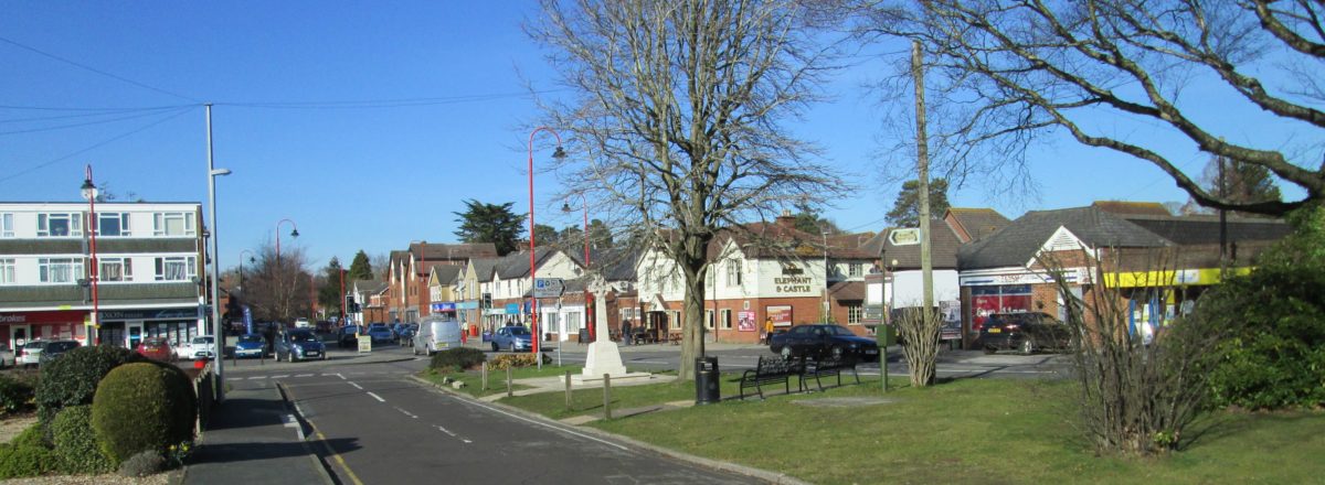
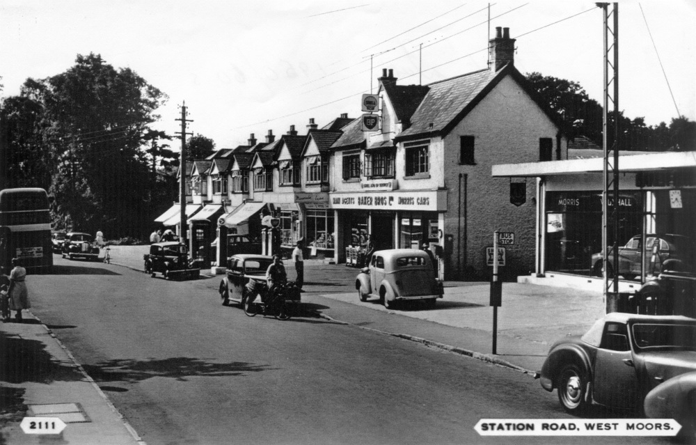
The second image shows West Moors Station Road shopping area, with lots going on … and a good illustration of how motor transport is now part of everyday life, including the garage / car showroom right in the heart of the village. The bus is heading off to Ferndown & Bournemouth … much more convenient than the railway!
More next post ….
… In 1955, British Railways as an organisation made an operating loss for the first time – that is, receipts did not cover running expense; this gave added impetus to the newly published ‘Modernisation Plan’, whereby a decision was taken to bring steam traction to an end. Major withdrawal of steam motive power took place between 1962 and 1965, then a more measured decline until final operational use in August 1968 (last use on Southern Region: July 1967).
If the 1955 Modernisation Plan had been properly implemented, operating losses might have been reduced and the local network would have been equipped with diesel traction & a rational staffing & operating structure. However, nothing could stem the tide of traffic-loss towards the nation’s roads. In the late 1950s, large-scale introduction of diesel multiple-units (dmu) was thought likely, which would include our local routes, but in the end, nothing happened on the lines running through West Moors – the management at ‘Board’ level had lost interest: with financial restrictions imposed by central government bearing down, the ageing steam locomotive fleet would have to stagger on.
… In 1956, the first specific suggestion was put forward (picked up by local newspapers) to close-down both the Salisbury line and the old ‘main line’ through West Moors between Brockenhurst & Broadstone; it was shelved at the time – perhaps because both routes were still providing valuable ‘avoiding – Bournemouth’ pathways – and eventually became useful ‘workarounds’ during the Bournemouth electrification project.
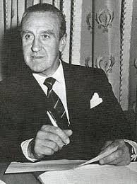
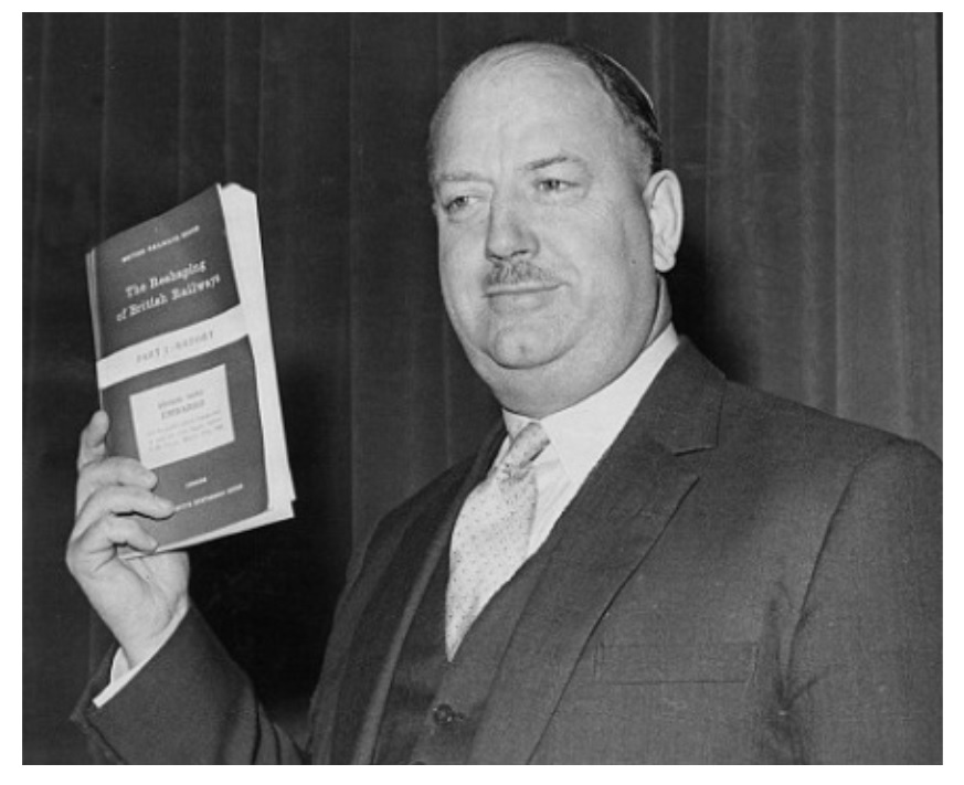
However, the appointment of Ernest Marples [ see first image ] in 1959 as (Conservative) Minister of Transport, given his strong links with the world of road construction, gave rise to (justified) misgivings about how committed the Conservative government was to the railways. In 1960, Prime Minister Harold Macmillan, was already talking about Britain’s railways having to ‘re-think’ their role in the nation’s transport infrastructure. It was clear that lightly-loaded, out-dated & expensive-to-maintain local railway services were on the way out.
Another factor coming into play around this time was the reluctance of youngsters to get involved with what was still a ‘dirty’ industry, given the highly labour-intensive method of operating steam traction: it was now the early 1960s and young men especially were drawn to ‘brighter, lighter’ industries. Moreover, pay was poor – when compared with like concerns – and the lure of a secure job and being part of the railway ‘family’ was no longer enough, as it had been for their fathers and grandfathers.
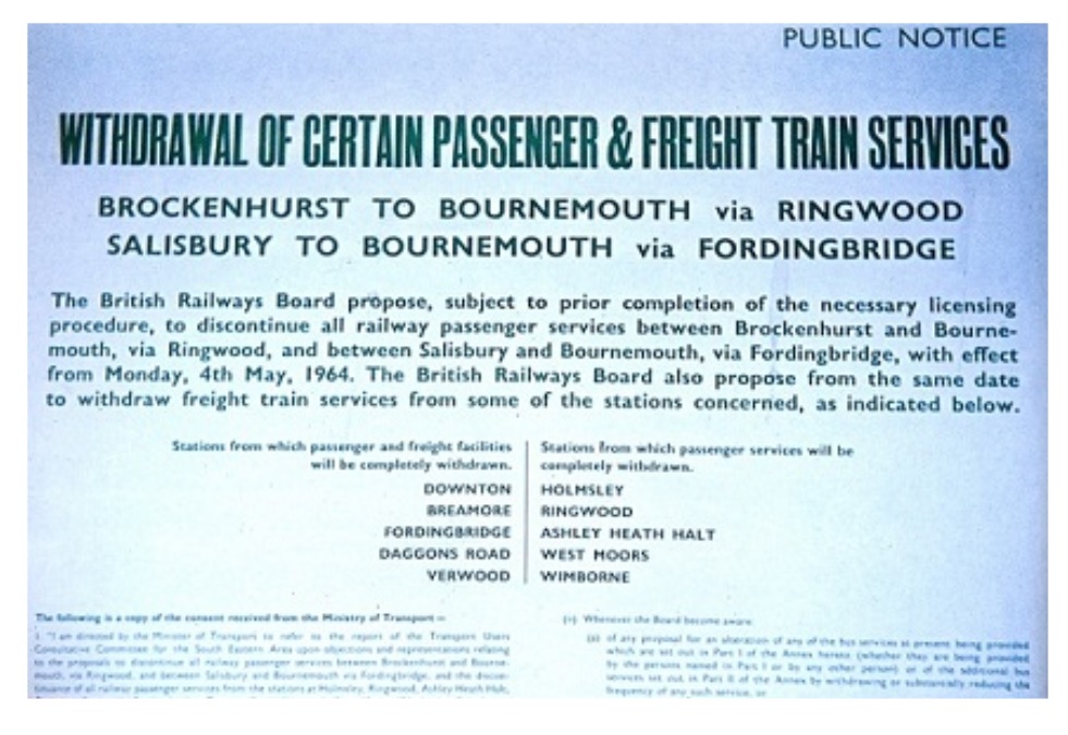
March 1963 will go down as the date that sealed the fate of our local railways – the publication in that month of the ‘Beeching Report’ ( strictly … ” The reshaping of British Railways ” , whose lead author was BR Chairman, Dr. Richard Beeching. [ second image ] ); the report recommended the closure of the lines between Lymington Junction & Hamworthy Junction (part of the original Southampton & Dorchester Railway main line), the entire Salisbury & Dorset Junction Railway (through West Moors) and the Somerset and Dorset Joint Railway (which meant everything north of Holes Bay junction). Railway branches had been closing for many years of course: the Ringwood – Christchurch line closed way back in 1935, but this was a thunderbolt ….
Ernest Marples, Minister of Transport in the Conservative government in the early 1960s.Dr. Richard Beeching, then Chairman of the British Railways Board, with his ‘infamous’ “Beeching Report”, or more correctly … The Reshaping of British Railways.
… Despite opposition, some of it decidedly lacklustre, the result was never in doubt. Formal closure notices [ below ] were issued for all lines through West Moors Junction in early summer 1963, to take effect in 1964.
Withdrawal of all service (passenger and goods) on the Salisbury line, and shut-down of the passenger service west of Brockenhurst on the Ringwood-West Moors-Wimborne line was set for Monday 4th May, 1964. However, as there were now no Sunday services, the actual last day of service was Saturday 2nd May, 1964 and of course as with many such closures around this time, the last services were well patronised.
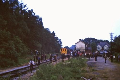
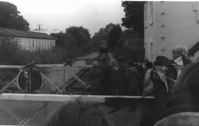
The last timetabled train to leave West Moors was the 9.29 p.m. to Bournemouth: once it had puffed across Station Road heading towards Uddens & Wimborne, the lights could be put out and the station building ceased its useful life. Apart from a few railway enthusiasts, it is doubtful if many local people were around after nightfall to see its tail lamp disappear among the trees lining Mannington Brook.
The quiet of the station as the new week dawned was in marked contrast to the feverish activity that was to develop elsewhere in the village in the months and years ahead: cement mixers, diggers, brick lorries and builders supplies trucks would transform the ‘village’ of West Moors into the ‘small-town’ community that we have today.
The railway would in fact linger on for another 10 years to West Moors – to service the Fuel Depot – but as most fuel was now moved via underground pipe networks, railway movements, apart from occasional enthusiasts ‘specials’ were very limited. After 1974, the railway would fade into memory.
And where once Dorset’s first main-line penetrated the county and entered the life of its people, is now part of the Castleman Trailway.
This is the end of this posting of some of my presentation slides.
Notice published which was the ‘death knell’ for many of the local railway lines in this part of Dorset.Last working of a passenger-carrying train to West Moors. Not a ‘high-vis’ jacket in sight: how did we survive?The last train to carry ‘passengers’ ( an enthusiasts special ) leaves West Moors road crossing heading back to Wimborne. The old station building long after it had finished its railway life – waiting for demolition. The single line runs away into the Fuel Depot, though I fancy that the last train has gone – this must be sometime in late 1974.“First and Last”: the old railway bridge over the Moors River east of West Moors – the county boundary ( Dorset / Hampshire ) used to run down the river until 1974 and it was at this point that the original main line into Dorset entered the country in the 1840s.