[ THIS PAGE NEEDS SOME SIGNIFICANT CHANGES: I HAVE SEEN ENOUGH EVIDENCE NOW TO ACCEPT THAT ‘WEST MOORS’ AND ‘LEONARDS BRIDGE’, ST. LEONARD’S SIDING’, ‘LENARDS CROSSING’ ETC., ARE ONE AND THE SAME PLACE. I’LL CHANGE TEXT (IN A DIFFERENT COLOUR FROM ORIGINAL – WITH DISCUSSION) WHEN TIME ALLOWS. (WRITTEN 10 MAY 2023) ]
It is often stated that there was a ‘halt’ at West Moors, before the station building was opened in 1867. What is the evidence for this assertion?
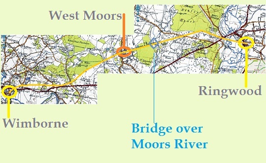
The main line between Ringwood & Wimborne was opened (as part of the Southampton & Dorchester Railway) in 1847. At that time, all we know definitely is that there was a crossing-house / gate (or gates) at West Moors.
Not long after the line was opened, a letter was written by a ‘Mr Fryer’ of Wimborne, suggesting that passenger trains (note … passenger trains, not freight) should stop at West Moors siding when signalled to do so. This is referred to in “Castleman’s Corkscrew“, by B.L. Jackson (see references elsewhere), and Mr Jackson then writes … “It is assumed that the West Moors siding referred to was in fact a passing loop known as Leonard’s Bridge situated between Ringwood and Wimborne, which appears to have been abandoned when the section was doubled.”
Now, who is this ‘Mr Fryer’? From various web sites (e.g. Wimborne Minster Town Council), a John Fryer was, in 1842, manager of the National & Provincial Bank (formerly the Wimborne, Poole & Blandford Bank and/or Dorset Bank) and in 1848, ‘John Fryer Esq.’ is listed as ‘Gentry’, so it could be he. John Fryer, from the inscription on the Fryer tombstone at Kinson, died in October 1854 (aged 57), so he would certainly have been active in the years following the opening of the railway. But of course, there are other Fryers in the area – and all had links with the small hamlet of West Moors.
Why did Mr. Fryer want the trains to stop at somewhere that hardly boasted anything to stop for? And apparently, it had a ‘siding’! Also, contrary to the remark by Mr Jackson (above), given that Mr Fryer was a long-standing resident of this part of Dorset he would certainly know where ‘West Moors’ was (at least as a designation & ‘name’ of the crossing house), and there is no logical reason why “Leonard’s Bridge” should be assumed to be at West Moors.
My suggestion is that there was indeed a siding (in the classic sense – i.e. a small, terminated line running off a ‘switch’) here in West Moors, though what its function was is not totally clear.
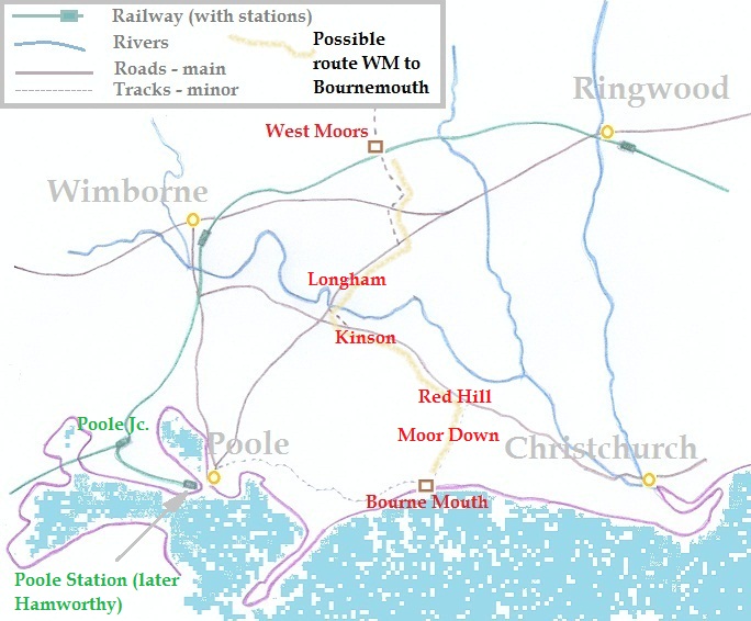
A local ‘legend’ is that rather than wealthy passengers with their carriages, horses and attendant groom(s) continuing to Poole (via what is now Hamworthy Junction) to trek across Poole Heath to reach ‘Bourne Mouth’, they would offload at West Moors crossing and continue their journey south to the growing resort cross-country.
This is the entry in “West Moors for Ferndown” (see references elsewhere): “By road, the only available bridges across the Avon were at Christchurch and Ringwood and over the Stour at Iford and Longham. [……] Over the bridge at Longham was a better direction to take as it was flat through Kinson and on to Redhill. Along the river bank, up to Moordown and so into Bournemouth. With the coming of the Railway to West Moors this became one of the favourite routes into Bournemouth for a number of years, until the railway was extended further into the town …. For the wealthy Mill owners and the people from London and Northern industrial towns, who had money to build and live in a garden town like Bournemouth, a special siding was built at West Moors. This enabled the last two wagons of the train, a horse box, for horse and groom and a flat bed wagon for the carriage to be shunted into this siding.” [ All this must be pre-1870, as there was no need for ‘cross-country’ work once the railway had reached Bournemouth – this happened in March of that year, when the Ringwood, Christchurch & Bournemouth Railway opened its extension to Bournemouth (East) station, situated on the eastern side of Holdenhurst Road.]
Now, I don’t know what his (i.e. Wiseman’s) sources were for this – he doesn’t list them in his book; the publication is written as if he dictated his memories and they were written down. He wasn’t around in the 19th century, but if he was an ‘aware’ youngster in the 1920s, and by all accounts he was, then his grandparents & great uncles (mentioned in the book) would perhaps have told him of all this – they having been working for the railway.
The activity mentioned is logical: the ‘official’ route to Bournemouth would be via the rather tortuous method of changing at Poole Junction (later named Hamworthy Junction, now just Hamworthy) and continuing to the only station for Poole, which was situated at the ballast quay on the other side of Poole harbour. Transhipment of carriage / horses would mean two changes (at Poole Junction & Poole/Hamworthy), with a toll bridge (apparently with precariously steep & narrow approaches), crossing to Poole ‘proper’, then the climb up the hill to and across Poole Heath (itself intersected by minor river valleys) to get to Bournemouth.
The method of slipping carriages / wagons at West Moors then proceeding across relatively ‘easy’ country via Longham (Poole Turnpike), Kinson (Christchurch – Merley track), Red Hill and Moordown would have been much preferred. The map (below) shows the lay-out of the area with some of places mentioned here.
There certainly was a railway crossing point listed at Leonard’s Bridge (wherever this is) – it is shown in the Inspector’s report on opening of the railway in 1847, and on the Hampshire (Crutchley) railway map [ I am now of the opinion that this is simply an ‘artefact’ of the mapmaker and not a ‘real feature’ – ignore this second comment ] of 1855, a round ‘blob’ is shown on the Hampshire side of the Moors river; as ‘St. Leonard’s Bridge’ is shown on the Ringwood Turnpike not far away, which would have been a major landmark in these times (much as Longham & Iford Bridges were/are), it would seem natural to name this ‘station’ (one porter, one policeman [i.e. a signalman/points-man]) after this nearby feature. Also of course, St.Leonard’s Common (but often shown as “Woolsbridge Common” on early maps) was just over that bridge on the west side of the Moors River; And there is a community of ‘St. Leonard’s’ on the eastern side of that River – but it wouldn’t be confused with West Moors! [ But perhaps this is where the confusion arises: the ‘Leonards’ allusion is to the moorland tract NOT the bridge? ]
Why there was a passing point (or ‘station’) here is not clear; after all, it’s not that far away from Ringwood! Another mystery in respect of ‘Leonard’s Bridge’ is that it doesn’t figure in the various railway timetables of the period. Was this provided solely for some local landowner and was abandoned soon after the opening of the railway? It can’t just be a goods pick-up point or it wouldn’t have been listed in the original opening set as having a porter & policeman. And, given that the nearest ‘natural’ feature is something called ‘Lions Hill’, I wonder if the stopping point was supposed to be called ‘Lions Hill Bridge?’
The problem with Leonard’s Bridge is that the distances listed in the Inspector’s report don’t match anything ‘on the ground’.
From the listing in “Castleman’s Corkscrew” we have (local section only):-
Ringwood … 23.25 miles [37.4 km] (from Southampton)
Leonards Bridge … 29.75 miles [47.9 km] (-do-)
Wimborne … 34.50 miles [55.5 km] (-do-)
This implies:- distance
Ringwood to Wimborne=11.25 miles [ 18.1 km ]
Ringwood to ‘Leonards Bridge’=6.50 miles [ 10.46 km ] (i.e. 6.50/11.25 or 0.58 [58%] of the way from Ringwood, whatever the ‘real’ distance)
‘Leonards Bridge’ to Wimborne=4.75 miles [7.6 km ] (i.e. 4.75/11.25 or 0.42 [42%] of the way from Wimborne, whatever the ‘real’ distance)
In reality, these (under) are the distances [along the line of the railway]
Ringwood to Wimborne = 9.50 miles [15.29 km ] (c.f. above). This from the mileage listed in the various published timetables of the first couple of decades of the 20th century. Adjusting for the fact that the distances in the original are incorrect, so that the true distances should read:-
Ringwood – Leonards Bridge:- 5.51 mi [ ~8.87 km ]
Leonards Bridge – Wimborne:- 3.99 mi [ ~6.42 km ]
… then measuring off along the railway 8.9 km from Ringwood gives the line crossing Uddens Water at Ameysford: why should this be annotated as ‘Leonard’s Bridge’?
And in any case, it goes against the map shown below. We can abandon this line of reasoning as there is no association with ‘Leonards’ at this point – it has a perfectly good name of its own – and there was no bridge here.
If we accept that Leonard’s Bridge was indeed 6.5 mi (10.5 km) from Ringwood, then this comes out at around Stapehill, at the back of the modern industrial estate, and nowhere near anything that needs bridging. If we accept that Leonards Bridge was 4.75 mi (7.6 km) from Ringwood, then this comes out close to where the eventual junction with the Salisbury-West Moors line was (though obviously not there at the time). Again, nothing needs ‘bridging’ at this point.
I’m pretty sure [ though now think I was wrong at the time of writing the original] that ‘West Moors siding’ (John Fryer) and ‘Leonards Bridge’ (Inspection report / Hampshire railway map) are two different places. I can’t believe the surveyors for the railway map got the location of Leonards Bridge so wrong as to place it at West Moors rather than north of ‘St. Leonard’s Bridge’ (on the Turnpike). Also, why call anything at West Moors ‘Leonards Bridge’? West Moors had a name associated with the crossing and NO bridge and Ameysford also had a perfectly good name of its own, or they could have used the name of the adjacent crossing – Dolman’s Lane. [ But again, it looks as if this discussion is ‘specious’ to say the least! ]
So, was there a ‘halt’ at West Moors? My suggestion is that trains were ‘halted’ on request (at time of booking, NOT on-the-spot) to allow detachment / attachment of wagons used to travel cross-country to/from Bournemouth and also, perhaps, to allow local produce to reach Wimborne and/or Ringwood – this would certainly tie in with the growth of the Stewart’s Nursery enterprise in the 1860s. Also, we can speculate that, as Gulliver’s Farm (with which family the Fryers were associated by marriage) is not far from the crossing (and possible siding), perhaps shooting parties needed to be conveyed from and to Wimborne on irregular occasions? Apparently the Farm had a ‘game’ licence and on the 1841 census, a gamekeeper ( Whitcher ) is shown as the entry immediately before that for ‘Hatchard’ (believed to be the tenant of Gulliver’s Farm at this time – the modern ‘Hatchard’s Copse’ is at the southern end of the farmland attached to Gulliver’s Farm), though there is no gamekeeper shown on the 1851 census.
However, it wouldn’t be the classic unstaffed halt that we know from later railway operations.