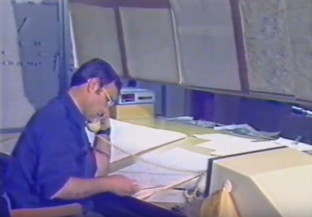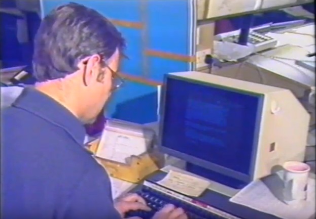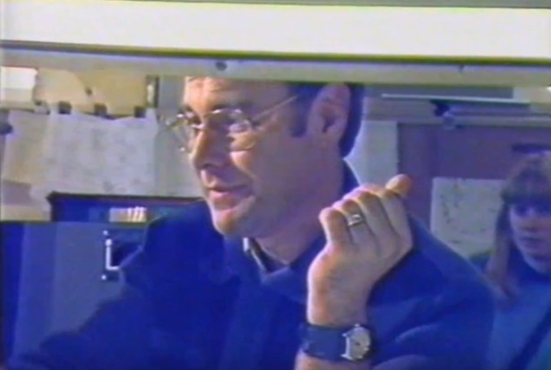
I was the night duty radio forecaster at London Weather Centre (LWC) on the night of the storm – 15th/16th October 1987 – and for several hours at the end of that night, was probably the only ‘official’ meteorologist available to the print / broadcast media.
These are my notes I made both immediately after the October 1987 storm, and 20 years later; also some additional notes etc.
After I finally got home on Saturday 17th, shattered, I took a day to recover [I’d probably get an intensive course of PTSD counselling now!] but then realised that there would be an enquiry, and I wrote up my experiences (in long-hand initially) ready for a call to LWC to appear before an enquiry. No such call came; I still wonder why. I spent the entire two weeks of my (pre-booked) leave fully expecting some sort of query as to our actions that night – and when I returned to work, I submitted the text below to the Principal Meteorological Officer (P.Met.O.), LWC (Roger Hunt), pointing out at the same time that never again should a TV Centre forecaster work on the Main Bench roster in LWC: they were simply not experienced enough in the procedures to handle a fast-moving situation & were more used to taking guidance from elsewhere rather than thinking independently when things were going wrong. Bear this comment in mind when you read the text – I attach no blame to the Senior Forecaster that night – he was simply out of his depth.
Also, bear in mind that even if the day shift had predicted the outcome with 100% accuracy, and if we had issued appropriate warnings several hours earlier than occurred, the trees would still have fallen, transport would still have been widely dislocated, buildings would still have been severely damaged and, sadly, people would still have died.
We (and I include myself) didn’t do well and got a deserved ‘kick up the bum’ for the poor effort. I just hope none of you reading this has to go through that sort of experience in your lifetime.
[The text below was written 20 years after the event and was intended to be an article for “WeatherEye” (Ian Currie’s publication); I can’t for the life of me remember whether I sent it to him or not! Anyway, here it is … a two-decade on view of events on that night ….]
Is it really 20 years? Even now the events of that night haunt my darker dreams.
It was the evening of the 15th October, 1987: I was the night duty radio forecaster at London Weather Centre (LWC), then in High Holborn. Those were the days when all national BBC radio forecasts were provided from the purpose-built studio on the street-level floor of LWC. Little did I think on that Thursday evening standing on platform 1 of St. Albans station [1] that I would not see the opposite platform until Saturday morning!
After the walk from Kings Cross Thameslink, I arrived, as was my custom, about 45 minutes early for my shift, which nominally started at 8pm [2]
After perusing the day’s charts and other data (for the Daily Weather Summary, both written [DWS] and broadcast issues), the night duty ‘general’ forecaster and I took a handover brief from the day staff. The ‘story’ was a slight backing-off on the wind theme – with more emphasis on the rain. Indeed, the wind was not really considered to be a ‘public’ forecast problem – more a ‘coastal’ threat.
We all settled down to our allotted tasks: 3 forecasters on the ‘main bench’ (for public & commercial land work) & other forecasters on the ‘offshore bench’ doing purely commercial work for North Sea operations (then provided from London).
The evening wore on, and the immediate weather story revolved around the remarkable change in temperature (and humidity) as the warm front wandered north: the screen temperature was around 9degC north of the warm front, shooting up to 17 as the southerly flow took over. Also, the very low MSLP pressure (eventually a record for central London, both for October & all-time, but since beaten for the latter) and the prospect of heavy rainfall. With each chart though [3], I became very uneasy, mainly on account of the magnitude of the pressure falls in the Channel / south coast areas.
The daily summary and preparation of the midnight broadcast (for Radio 4) were in progress, and I had roughed out the late issue of the ‘Press Areas’ forecast. I was aware (because they were near to my working position), that the Offshore Bench were ‘winding-up’ the warnings in the North Sea.
Falls of pressure coded as ‘100’ or greater (i.e. 10.0 mbar in 3 hours) were now being reported on the south coast: this, by the book [4], is an automatic cue for widespread land area gale warnings, and I knew in my bones that were were caught up in a major synoptic development.
We had a call from the advertising company responsible for the ‘Tell Sid’ British Gas flotation campaign – they had a huge banner displayed in central London and were getting worried about it – ‘take it down’ I said – I’m not sure to this day what happened to it.
In a real sense, we felt helpless as the development unfolded: there was little to be done at such a late stage – the opportunity for the issue of any kind of ‘public’ warning had long gone, and the best we could do that night was to alert the police, fire & local authorities that took our warnings service of what we knew. One call I remember was from one of ‘ours’: an off-duty forecaster from north of London who rang up to ask … “what’s going on!”
The rest, of course, is history. Effectively we were unaware of the drama unfolding outside our window; not only did communications become decidedly flakey, but given the time of night, we had little feedback from the outside.
By 5.55am, when I had to do the first ‘main’ broadcasts (Radio 3 vhf & Radio 4 ‘News Briefing’), we had the first intimation of the catastrophe suffered by many across the southeast of England. As each of the BBC ‘Locals’ kicked-in [5], it became apparent what the wider impact was: railways, roads, power and telephones all significantly compromised, as well as the unfortunate deaths – well over 20 I believe. [6]
Listening again to my broadcasts [7, 8], it is clear that I didn’t fully appreciate the scale of the destruction – on the early broadcasts I was only mentioning “branches & tiles” coming down: in reality, large swathes of the transport, electrical and telephone infrastructure of the SE had failed, with a loss of millions of trees. [9]
My nominal shift finished and to my amazement, my relief managed to get in by 0830, but because of the weight of calls from the media, and the failure of other forecasters to make it in, I stayed on to field the many press queries: my final effort was to be grilled by Julia Somerville for ITN (live) at 1pm: why did we get it wrong? I waffled something bland and non-committal, fearful of putting my foot in it in the absence of guidance from HQ at Bracknell. We couldn’t talk to anyone there as telephone contact had failed – I remember sending a Telex to the Met. Telecomms Centre asking for urgent guidance – no reply!
By now (early Friday afternoon), it was pointless to think of going home .. even if I could have got home! I decided to try and sleep on the floor of the conference room [10] – no mattress or blankets and my coat for a pillow. With the noise of London trying to cope with the aftermath of the storm, the drone of the stand-by generator (thank goodness the tanks were full) and the events of the night running riot in my head, you can be sure I did not get much sleep.
Early evening (Friday 16th), and a somewhat dishevelled Martin staggered downstairs to the forecast floor – I can’t have been too nice to be near, with no facilities to have a shower! No food either – all my ‘sarnies’ had been eaten early the previous night.
The second night, fortunately, was quieter – both ‘weatherwise’ and for the number of broadcasts: the only advantage of being on duty for the following night after a disaster is that nothing can be quite as bad! [11] Keith Best, the night-duty senior forecaster advised me to get some shut-eye, which fortunately I was able to do for a couple of hours in the back of the radio studio – it now being sufficiently less noisy: the generator had finally been shut down and the chain-saw gangs had gone to bed!
That Saturday’s morning’s broadcasts flashed by – I don’t remember much about it. No doubt I was asked again and again about the events of the previous night. At 8.15am, after doing the final ‘local’, I gratefully shut the door of the Weather Centre behind me and trudged back [12] through a landscape of fallen trees and collapsed walls.
Truly a ‘night to remember’ .. or to try and forget: to this day, when I’m under stress, my voice fails as a consequence of the many broadcasts / interviews I had to do with no sleep.
[Notes for this article (above) – written in 2017, NOT at the time of writing the article.]
-
- [1] St. Albans City / Thameslink (Midland) line.
- [2] I had established the practice of arriving at least one train before needed to allow for hold-ups.
- [3] Plotted on-site by the OASYS plotting system but we did have FAX charts as well.
- [4] Handbook for Public Services, the ‘bible’ for all non-military forecasting operations.
- [5] To a schedule long in operation – nothing to do with the events of the night.
- [6] I understand that the death toll attributed to the Storm is now (2017) 22, which includes deaths in France.
- [7] I ‘rescued’ the in-studio monitor tape when I did the following night duty – or it would have been over-written! Presumably there are other recordings somewhere?
- [8] With the modern power of You-Tube (not even a gleam then of course), you can find some of my poor offerings on that morning: they were not my finest work.
- [9] I couldn’t even ask the radio/tv stations calling in what the true extent of the damage was as no sooner had I checked in/established contact and given my response, the next station was frantically calling up – not to mention trying to field the calls from other (non-booked) media outlets and emergency services.
- [10] One floor higher than the forecast room level – LWC occupied three floors of the building.
- [11] I was the only one of the previous night’s ‘crew’ who was on again the next night.
- [12] Initially through Holborn and Camden to the railway station – then in St. Albans – though things weren’t quite so bad up there.
[ And this was the formal report I presented to P.Met.O, LWC on my return to work ]
Report on ‘N’ duty: 15th/16th October, 1987
M.G. Rowley
(all times ‘local’, i.e. BST: where in parenthesis, approx.)
My scheduled start time for the night duty is 2000 hr, but because I catch an earlier train, I arrived in the Office [1] at around (1925hr) and by 1930, I was having a preliminary look at the situation. (By getting an early start, I can get some of the ground-work for the D.W.S & midnight summary out of the way to concentrate on the weather). At (1950), when K** had also arrived, we took our hand-over briefing from the D3 (A*** S***)[2]. The main weather problem revolved around the movement of a cold/warm front – at that time to the south-east of London, & its subsequent movement. This was important because of CEGB/Gas [3] temperature forecasting considerations, & also because, in the warm air, surface winds were expected to (be) 30-35 kn (ex FM [Fine Mesh]), with one grid-point 40 kn [4]. The hand-over as to wind was that the main drive of strong winds was to be to the S.E. of London overnight (with strong winds in the Channel) & that by dawn, probably well before, the cold air would have penetrated across the London area – taking the strongest forecast winds away & giving us a “Pm” type of day with sunshine and showers. No particular concern was expressed as to the strength of the wind overnight.
At (2050) the SSO [5] (I** M********) called through to C.F.O. to check for any changes in story – as is routine. Apparently the CFO senior forecaster advised that the developing wave depression located in the Bay of Biscay would take a track more to the N.W. of London – specifically across the Midlands & N. of England. This meant that a further pulse of heavy rain could be expected over much of E & W (England & Wales) overnight, some of it heavy – this rain pushing into Scotland around dawn. I did not listen to this conference as this is not a requirement – but apparently no specific mention of overnight wind strength was made – or if it was – was not communicated to me. My own opinion was that the CFO (Central Forecast Office) S/F (Senior Forecaster) had OVER used extrapolation – & as the upper pattern was clearly still progressive, the low would exit UK land areas Humber/Wash areas. However, this did not materially affect the situation, as either way, simple amendment of the 12Z FM wind run would mean that 35, possibly 40 kn mean surface winds would strike much more of the country than the south-east – with gusts according to theory of at least 60-65 kn [6].
At (2145), I noticed that the London Fire Brigade warning [7] had not been issued, which I thought strange – & as the M/B SSO was absent, pointed this fact out to the O/B (Oil/Offshore Bench) SSO (Senior Scientific Officer) who was in the main bench area. He advised that I should issue warning which I had already decided to do, once I found out that I** had left apparently to get some refreshment. As I was un-used to using the Glossary term for the LFB warning – G**** offered to set it up & send & I signed the warnings form and entered it on the warnings board – advising I** of my action when he returned. At the same time – I suggested that with the obvious changes – the BR (British Rail) overhead [8] warnings would need extending.
At 2250, we were about to go on the warm side of the front, with the roof temperature rising several degrees in a short time soon after, with wind gusting, & the pressure falling. I realised that the way things were going, we would certainly achieve our all-October lowest pressure & perhaps the all-time lowest pressure – facts passed onto N & N3 (codes for the Senior and Local forecaster positions) for information.
Sometime between 2245 & 2300, upon arrival of the 2100Z chart, & new gust lists [9], plus the appearance of further heavy rain in places – I suggested that a composite/LWC “flash” [10] message be considered. I pointed out that INLAND gusts were now 50 kn or more and heavy rain – and at the very least, conditions were going to be difficult due to a combination of rain AND wind. The SSO did not agree a “flash” was necessary – but I said that . . . “if I were sitting in his chair – I would get onto CFO to talk about it at least, because this was ‘looking nasty'”. (This would be the latest time to get the widest possible broadcast dissemination).
At 2300, I had a broadcast on R210 [11] which covers the Thames Valley, then returned to the forecast room. This time then was spent (a) sending/amending the final “Press” (b) finalising UK summary for DWS (Daily Weather Summary) & (c) working on my 0020 script. I also sketch out in preliminary form the Inshore Waters forecast broadcast next morning. Whilst doing this latter job, it confirmed my earlier opinion that something “much windier” than 12Z FM run was brewing – & this was echoed by comments which I could hear coming from the Offshore Bench [12]. At (2345), I actually “compared notes” with the O/B SSO (Offshore Bench Senior Forecaster) & informed him of my wish to consider a “flash”. G**** advised me to use my own discretion on the broadcast & this I did.
The late-evening SR (Synoptic Review) was only just available to me before I went into the studio to check with OB (Outside Broadcast [BBC]) control – & the mention of winds in the SR did not appear to fit what was happening already – “gales/severe gales exposed areas in S.E.” seemed to be a hangover from the previous SR. I tried ringing upstairs – but after a few ‘rings’ with no-one answering – decided just to talk about “stormy” winds across southern Britain etc.
On my return to the F/Rm (Forecast Room) at (0030), the latest BI (British Isles) chart (2200Z) confirmed the rapidly developing situation – & I pointed out that many – if not all – of the warnings for RAIN were expiring / had expired [7].
I took it upon myself to issue all BR warnings necessary as I** seemed busy, but he did not seem to appreciate the seriousness of the situation.
S.W.C. (Southampton Weather Centre – who we ‘parented’) came through to discuss “flash” (0145-0215??) – & M/B SSO then contacted CFO. Even then, time was wasted when I found out that the Supervisor was ‘phoning EVERY wxcen (Weather Centre), not just the main centres.
I rang – on my own responsibility – LFB, Southern Water (0230 – 0245), to explain that this was no ordinary wind & called up the Police rain warning glossary term in my Processor & used it to send a message to all our Police units that v.stg winds were going to be a problem. Informed M/B SSO.
By (0330), it was apparent, with failing power [13] and calls on the public line – that a major disaster was upon us – & the rest of the duty was concerned with “clearing the decks” of routine work – preparing broadcasts – &, after 0500, answering increasing numbers of Media enquiries – listed elsewhere.
After I was relieved at 0830, I carried out the duties of D6/D7 (day-duty additional forecast positions) until 1300 – returning for my second N2 (Night-duty radio) at 1900 that evening.
[Notes on the text above – written in 2017, NOT at the time]
- London Weather Centre, High Holborn.
- Day-duty ‘general duties’ forecaster.
- CEGB = Central Electricity Generating Board (generating all electricity as a tax-payer owned facility). Temperature forecast curves were maintained for both utilities to predict demand.
- kn = knots, the common output of all models in the UK service; 40 kn =~46 mph =~74 km/hr.
- SSO = Senior Scientific Officer, I was an HSO, Higher Scientific Officer, one grade below.
- 60-65 kn =~ 69-75 mph
- All these warnings were the responsibility of the Main Bench SSO – unfortunately the person on duty that night hadn’t done the duty sufficiently often to realise that!
- I.e., the warnings of high wind that would necessitate slow-running due to possible damage to the OHE networks of the railway.
- These were printed out from the OASYS plotting system about H+35/40 each hour. To ‘manually’ call them up on the Graphics VDU was a slow business – and would slow down significantly the plotting facility. Early days of such technology and it left much to be desired.
- This was pre-NSWWS stuff: a ‘Flash’ message was so called because it was analogous to the MoD signal precedence ‘flash’ criterion which dicatated no hindrance to the message being disseminated: it was our highest order of warning and only issued very rarely. London Weather Centre (rather than CFO Bracknell) were THE authority for both a ‘national’ Flash, and for co-ordinating such between adjacent weather centres. It was OUR responsibility on the night.
- Independent Radio station based in Reading.
- Just behind my working position in LWC.
- Our emergency generator had ‘kicked-in’ but it could only power a proportion of the building facilities, so we lost important sources of data-feed.
That was my report on that night – written down whilst still fresh in my memory: I don’t seek to absolve myself of any responsibility for failing to do better, neither do I wish to damn anyone else. It’s just the way it happened.
Martin Rowley
West Moors
October 2017
Some images, taken as ‘screen shots’ from off-broadcast tv coverage at the time are set out below: obviously, not of high quality!